Majestic Suicide Rock
Suicide Rock situated at the mouth of Parley’s Canyon is a significant historic landmark.
December 29, 2012
LeRoy W. Hooton, Jr.
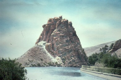
Suicide Rock and Parley’s Canyon Reservoir viewed looking down canyon towards the Salt Lake valley. Circa 1900

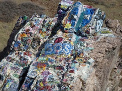
Situated at the mouth of Parley’s Canyon is a geological feature that has become the Salt Lake valley’s public art works. Suicide Rock (aka Sentinel Rock) has been a landmark for travelers coming and going through Parley’s Canyon for centuries. However, in modern times the rock has become the abode for those who use a paint brush or spray can to express their artistic urges.
Unfortunately, this has caused the public to see Suicide Rock as a painted rock, rather than the once majestic sandstone rock, standing as a monolith at the mouth of now Parley’s Canyon. It has been witness to the epochal history of the Salt Lake valley, including a land of native Americans, arrival of the pioneers, the California gold rush and seminal transportation and water development during the past several centuries.
Parley’s Canyon's name was first given by Brigham Young and later was changed in honor of Parley P. Pratt who explored, surveyed and built the road up this canyon. Shortly after arriving in the Salt Lake valley, the Mormon High Council met to name the valley's canyons and streams. On August 22, 1847, President Young named the canyons including now Parley's Canyon as “Big Canyon.”
Before the Salt Lake Valley was settled by the Mormon Pioneers, the rock belonged to the local Indians, where it is believed to have been a place for a lookout or sentinel. It got its name from a legend. The story goes that a broken hearted Indian maiden jumped from the rock to her death because her betrothed Brave had succumbed in battle – giving it the name of Suicide Rock.
The last leg of the pioneer’s 1,000 mile trek from Winter Quarters to the Salt Lake valley began at Henefer when it was decided to follow the trail used by the Donner-Reed party the year before. It began on the Weber River, then through East Canyon to Big Mountain Pass, then through Dell Fork to Little Mountain, and completing the journey down Emigration Canyon to the valley. It was a steep, brutal climb over rock and sage.
In 1848, Pratt was assigned the task by the High Council to find a better route for the large number of emigrants and travelers that would be coming from the East to the Salt Lake valley. Pratt explored a route from the Weber River to Kimball’s Junction to the summit and down Parley’s Canyon to the Salt Lake Valley, which he believed to be a better route than the original route through Henefer. Subsequently the High Council decided that a toll road be constructed to provide easier access to the valley. Pratt was given a charter to open the road as a private enterprise.
|
Pratt finished the toll road in June 1850 and named it the “Golden Pass Road” and placed the tollhouse in the general vicinity of Suicide Rock at the mouth of the canyon.
In 1851 after Pratt sold his interest in the road to finance his church calling to serve a mission, the road fell into disrepair. The Territorial Legislature approved a bill to make repairs to the road, which was the first step making it a public road. In 1862, a cut-off was constructed through Silver Creek Canyon. Over the years the road became public and part of the state and national highway system. The area between the mouth and summit became known as Parley’s Canyon and Parley’s Creek. Pratt’s entire Golden Pass Road would ultimately become the route for the current I-80 Freeway.
Gold seekers from the East traveling to California in search of riches, used the Golden Pass Road. The image of Suicide Rock welcomed this multitude as they entered the Salt Lake valley enroute to fulfilling their quest for gold. One wonders if some camped near the rock and drank the waters of Parley's Creek as they prepared to cross the grueling Great Basin desert to reach California.
Both Pony Express overland mail service and stagecoach service used Pratt’s Golden Pass Road in the late 1850s and 60s. A way-station was situated at a site where Mt. Dell reservoir is now located. Riders and coaches would pass within feet of Suicide Rock as they traveled to and from the Salt Lake valley.
From 1888 to 1956, trains ran on tracks that were laid on the south side of Suicide Rock. In 1888, the first railroad tracks were laid from Salt Lake to Park City through Parley’s Canyon by the Salt Lake & Eastern Railroad. The Company was purchased by Rio Grande Western Railroad in 1897. The last train to run in the canyon was in 1956. The tracks in Parley’s Canyon were covered with fill when the Interstate I-80 freeway was constructed several years later.
In the same vicinity of Suicide Rock are numerous waterworks facilities. Built in 1892, the left abutment of the Parley’s Canyon Reservoir dam was anchored into Suicide Rock. The dam and diversion point were part of the exchange of water with the farmers using Parley’s Creek. The 1.6 million-gallon reservoir was the head works to the Parleys Lower Conduit that conveyed Parleys Canyon Creek water approximately 6 miles to the First South and 1300 East Reservoir.
|
Today, the area around Suicide Rock remains a key water distribution point. In 1988, a new regulator station was constructed to allow the Parley’s Conduit from the Parley’s Water Treatment Plant to be pressurized forcing water to both the north and south to feed the bench service area by gravity. This eliminated much of the pumping required to serve the higher elevation zones of the distribution system.
In 1967, I-215 was constructed across the outlet of Parley's Canyon and west of Suicide Rock. A large amount of fill was used in the construction, elevating the freeway above the elevation of Suicide Rock, so that the west side of the rock can be seen from the freeway. The freeway embankment is now part of the Parley's Trail a popular segment of the Bonneville Shoreline Trail system.
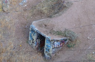
Near the base of Suicide Rock young people have found that the creek provides a popular tubing experience. Called “shooting the tube,” youngsters float through the creek culvert under I-215 for a distance of about one-quarter mile. By temporarily blocking the inlet to the culvert, and then quickly releasing the stored water an artificial wave pushes the floaters through the culvert at an accelerated speed.
Notwithstanding the perception that Suicide Rock is now an un-natural painted rock , it continues to be a majestic sentinel watching over the Salt Lake valley and Parley’s Canyon, and should be remembered as an important part of our history.

