National Drought Conditions Deepen
A dearth of precipitation and sweltering temperatures plunges much of the U.S. into drought.
August 28, 2012
LeRoy W. Hooton, Jr.
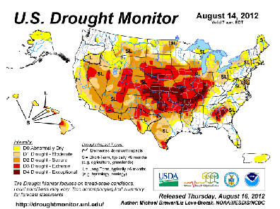
Figure 1. U.S. Drought Monitor

Not since the 1930s has drought affected such a large expanse of the continental United States (U.S.), affecting 32 states. This phenomenon has been caused by abnormally low precipitation and warmer than normal temperatures over an extraordinarily large area of the nation. According to the National Oceanic and Atmospheric Administration, July was the hottest month on record. These climatic conditions have continued through August deepening the drought with no apparent change in sight. Depending on the duration of the drought it could have significant impacts on the nation’s land, water and agricultural resources.
According to data from the U.S. Drought Monitor August 14, 2012 Report, over 60 percent of the nation has experienced extreme to exceptional drought conditions (See Figure 1.). The most severely affected regions include the central Rockies (including Utah) eastward through the Mississippi and Ohio River Valleys. Hardest hit is the nation’s breadbasket located in the mid-west and Great Plains states, where the drought has put at risk one-half (rated poor to very poor) of the region’s corn crops according to the U.S. Department of Agriculture. Moreover, sorghum and soybeans production are predicted to be much below normal this growing season.
The U.S. is a major exporter of these commodities to world markets. The prospect of reduced production and exports of these commodities is causing alarm in foreign nations where reduced food supplies may mean potential famine in the poorer nations. In the U.S., grocery prices most likely will rise as a result of the drought.
The nation’s rangelands are not fairing much better. Within the contiguous 48 states as a whole, 59 percent of pastures and rangelands are rated as poor or in very poor condition with extremely low soil moisture, not only threating crop yields, but the ranching and cattle industry as well.
A bellwether of the extent of the drought is the flows in the Mississippi River. Collecting water from approximately 25 percent of the continental U.S. land area, the Mississippi is the largest river in the nation. The river's watershed drainage covers nearly 1.2 million square miles that lies between the Rocky Mountains on the west to the Appalachian Mountains on the east. The drought has had a significant effect on the flows of the river, reducing the commercial barge traffic moving cargo from the nation's heartland to both national and international markets. By mid-August the water levels have dropped 50 feet below last year’s levels along some segments of the river. In some locations, water levels have declined to only 5 feet deep, making it difficult for some barges to operate on the river. Some companies have reduced their cargo loads by as much as 25 percent in order to operate at these extremely low levels.
|
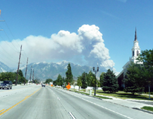
Wildfires continue to consume forest and rangelands in the West. By August 16 of this year, wildfires had burned through 6.47 million acres, surpassing the 6.36 million acres burned by this date last year, according to the National Interagency Fire Center. This is about 3.4 million acres short of the record set in 2006, when 1,801 fires burned a total of 9.87 million acres, according to center statistics. However, the 2006 record may yet be surpassed as there is still a long burn season remaining this year.
Closer to home, the drought has affected the Colorado River Basin, the largest source of water supply for Utah and six other basin states of Wyoming, Colorado, Nevada, New Mexico, Arizona and California. Water from the Colorado River supplies the Central Utah Project, which is a major source of water for the population residing along the Wasatch Front. Last winter’s poor snowpack has drastically reduced the Colorado River flows. The Drought Monitor August 14 Report shows the basin is under severe or extreme conditions, resulting in flows less than half the normal.
According to the National Weather Service’s Colorado Basin River Forecast Center the observed unregulated inflow into Lake Powell for April through July was 2.06 maf or 29 percent of average; for the month of July 2012 it was 0.154 maf or 14 percent of the 30-year average from 1981 to 2010. The forecast for August 2012 is 0.200 maf or 40 percent of the 30-year average. Projections are that Lake Powell and Mead reservoir volumes will decrease by more than 4.3 maf in 2012. Fortunately, snowpack and run-off flows were above average in 2011, which raised the levels last year mitigating the impact of the drought this year.
In Utah, the drought has not been as severe as other areas of the nation. Reservoirs were filled two years ago when they received copious snowpack and run-off. For example, the local Wasatch Canyons streams in Salt Lake County produced flows that were 169 percent of normal. Utah’s carry-over storage this past year was a record high, which for the most part has provided an adequate water supply during this summer’s high demand period.
State-wide, according to the U.S. Natural Resource Conservation Service, Utah’s reservoir storage on average has dropped from nearly 100 percent full at the end of spring to 70 percent in August. The Provo River-Utah Lake-Jordan River basin reservoir storage stands at 82 percent. The Sevier basin currently has the lowest storage at 47 percent. With several months of high water usage remaining, reservoir storage will continue to decline – hopefully leaving some carry-over water for next year if the drought continues into another year.
|
Salt Lake City’s water supply this year is being met by a combination of water sources, including canyon streams, stored reservoir water and wells, according to Public Utilities' hydrology specialist Larry Alserda. The Wasatch Canyon streams [in August] are noticeably lower than normal this year. “…from all appearance Big Cottonwood creek has most likely the lowest flows seen in a decade,” says Alserda. Likewise he continues, “Dell Fork stream in Parley’s canyon is noticeably lower than normal – it’s as low as I have ever seen it.” The City’s Public Utilities is meeting its irrigation exchange contracts with Utah Lake water and ground water wells, notes Alserda.
Looking to the future, it’s uncertain if the drought will deepen or weather conditions return to more normal conditions. Historically, in the 20th century, there have been both wet and dry periods occurring in capricious cycles. Until this year, the drought of the 1930s was the most severe, lasting nearly a decade and created the dust bowl in mid-America. The current drought is different, in that it has reached severe status in one year, following the record 2011 wet year. If it continues along its current path, the drought could cause serious consequences for the U.S. and foreign countries relying on its agriculture exports.

