Poor Western Snowpack Forebodes Below Normal Water Supply Forecast
Streamflows may be the lowest in a decade or even worse.
May 23, 2012
LeRoy W. Hooton, Jr.
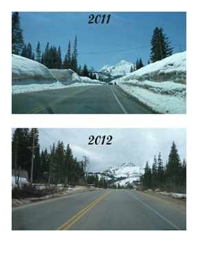
Snowpack comparison photos in Big Cottonwood Canyon near Brighton taken on the same days of April 17 in 2011 and 2012. The snow depth was over 10-feet high in 2011.

After last year's copious snowpack and heavy run-off, the pendulum has swung in the opposite direction this past winter with below normal snowpack and a forecast of well-below normal run-off this year. The contrast is amazing; from a near record year to projections of one of the poorest water years in recorded history.
The lack of snow this past winter covers the entire West, raising widespread water concern – especially on the over-appropriated Colorado River, which supplies water to seven basin states. The run-off forecast for this critical water supply is 45 percent of normal this year. Aggravating the situation, the snowpack in some locations below 10,000 feet melted five weeks early.
According to the Natural Resource Conservation Service May 1 report, the snowpack was the lowest recorded in 45 years of record. Improved system storage may mediate the poor run-off. The U.S. Bureau of Reclamation reports as of May 9, the total reservoir storage in the Colorado River Basin was 37.07 maf (62.2 percent of average), an increase of 14.5 percent resulting from the high 2011 run-off of 147 percent of normal. Hydrologic conditions and demand on the river are expected to decrease reservoir storage this coming year.
Water shortages within the Upper Colorado Basin have a ripple effect on each of the states tied together by a compact signed in 1922. Historically, during periods of water shortage on the river, conflict develops among the water partners. For the foremost, these flaps have been resolved through negotiations. The most recent example was the 2009 Seven-State River Shortage Agreement, which established new rules for the coordinated operations of Lake Powell and Lake Mead, with guidelines for dealing with shortages and surpluses on the river. This agreement was in response to alarmingly low water levels in Lake Mead resulting from the basin drought from 1999 to 2005.
Salt Lake City is tied to the Colorado River through the Metropolitan Water District of Salt Lake & Sandy. The District receives water supplies from the Provo River Project and the Central Utah Water Project, which rely on water from tributaries that flow to the Colorado River. On May 15, the Provo River-Utah Lake-Jordan River basin snowpack (SWE) was 16 percent of normal.
A major source of Salt Lake City's water supply comes from the Wasatch Canyon watersheds located along eastern Salt Lake County. On average about 80 percent of its municipal water comes from the canyon streams. The streams also provide irrigation water to meet the City's exchange agreement obligations.
|
NOAA forecast projections for the western U.S. indicate the run-off from the Wasatch canyon streams is below normal: City Creek, Dell and Mill Creek are forecast to flow at about 40 percent of normal; Emigration 23 percent, Big Cottonwood 56 percent, Little Cottonwood 61 percent and overall Parleys watershed 19 percent. Mid-elevation snowpack in the Wasatch disappeared by mid-April this year.
In regards to this year's Wasatch snowpack, Public Utilities' hydrology specialist Larry Alserda made some comparisons: “The 2007 snowpack seems to be close to this year’s snowpack, which yielded a streamflow volume rated 82nd lowest out of 91 years of stream flow records.” He further commented, “ Eight of the lowest 20 annual stream volumes have been within the past 10 years (2012 included),” indicating that the watersheds are receiving less than normal snowfall over this period.
The lower elevation watersheds have peaked early with notable low flows according to Alserda. Mill Creek peaked at 111 CFS on June 24, 2011 and peaked at 14 CFS on May 3, 2012. Parleys peaked at 320 CFS on May 24, 2011 and 46 CFS on May 3 this year. Emigration got to 80 CFS on May 30, 2011 and only 5 CFS on April 27 this year. City Creek reached 162 CFS on June 16 last year and 27 CFS on May 9 this year. It's noted that last year's peak flows were abnormally high, and this year's values are also abnormally low.
Only the Cottonwood streams have yet to peak. Last year Little Cottonwood peaked at 653 CFS on July 3 and so far it has reached only 207 CFS. Big Cottonwood got to 698 CFS on May 24, 2011 and has reached 150 CFS so far this year.
Despite the lower run-off forecast, offsetting this is the fact that the state's reservoirs are filled from last year's plethora supply of water. In the Provo River-Utah Lake-Jordan River drainage, Utah Lake is above compromise level with 900,000 acre-feet of storage. Jordanelle Reservoir and Deer Creek Reservoir are expected to fill.
At this time with the healthy reserve of stored water, the threat of severe shortages this year appear slim.
