Living In the Arid West
Historically, Westerner communities have struggled to overcome the aridity of the West.
September 26, 2012
LeRoy W. Hooton, Jr.
In a region of the United States where water is scarce, Westerns have and will continue to be challenged in their efforts to develop sufficient water to sustain agriculture and urban populations located west of the 100th meridian.
History has shown the hardships and eventual success of the early Mormon pioneers who conquered the unforgiving western environs of the Great Basin by developing the organized practice of irrigation. Their success became a model for other western settlers who followed in their footsteps. Once established, irrigation on a grander scale was made possible by the enactment of the federal 1902 Reclamation Act, based on the Mormon pioneer’s experience and water laws.
During the 20th century the Bureau of Reclamation built huge projects that developed irrigation water and electrical energy to fuel growth across the Western landscape. Besides increasing reclaimed land for agricultural production, megalopolises sprang-up throughout the west. This has required the construction of expansive infrastructure to manage and convey water to where it’s needed.
|
One of the first water projects built after passage of the Reclamation Act was the Salt River Project in Arizona. The genesis of this project began in 1867, when former confederate soldier Jack Swilling led a band of about 20 miners into the Salt River Valley of the Arizona Territory to re-excavate a prehistoric Indian (Hohokam culture) canal and built a dam across the Salt River. The water diverted from the river was used to irrigate several hundred acres of corn, wheat and barley. Patterned after the Mormon neighbors to the north they formed the Swilling Irrigation and Canal Company. Stock was issued and assessments made to generate capital and to operate the cooperative association. From this modest beginning, the settlement and later the city of Phoenix grew into a major urban community, including Tempe, Mesa, Lehi, Glendale, Peoria and Scottsdale.
As the population continued to grow in numbers, the need to manage the Salt River became more critical to the community. River flows would vary from year to year with periods of drought; then enormous flood events would wipe out farms and communities downstream. This phenomenon rallied public support for action to manage the river’s flows. They petitioned the federal government to aid them in this endeavor.
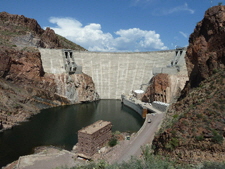
The Salt River Project was one of the first federal projects authorized under the Reclamation Act, which included improving existing dams and irrigation canals and construct new dams on the Salt River. A key feature of the Project was the Theodore Roosevelt Dam. The dam site, located about 76 miles northeast of Phoenix had favorable geological formations with a large valley to store the water behind the dam. The federal government felt that the project was an ideal project to demonstrate the worthiness of the new federal legislation. There was strong local support and ample fertile farmland to repay the government loan necessary to finance the local costs of the project. It was the first multipurpose project under the reclamation act.
The Salt River Valley Water User’s Association was formed to sponsor the project and repay the reimbursable costs. The first stone of the cyclopean-masonry gravity arch dam was laid in September 1906. The dam was completed in 1911. Originally the dam was to be named the Tonto Basin Dam; however, in the end it was named after President Theodore Roosevelt. On March 18, 1911, former President Theodore Roosevelt dedicated the dam. As his car approached the dam, eleven guns on the dam discharged followed by the cheers of about 1,000 people attending the ceremony. Roosevelt said the two proudest achievements of his administration were the Reclamation Act and the Panama Canal.
The dam structure stood 280 feet high with a crest length of 723 feet. The base width was 184 feet and the top width on the crest 16 feet. The spillway maximum capacity was 150,000 cfs, and the outlet works 3,160 cfs. The power plant had a generating capacity of 36 Megawatts. The reservoir’s capacity was 1,336,734 acre-feet covering 17,337 acres
|
In 1994, the dam was modified to comply with Reclamation’s Safety of Dams program. The original dam structure was upgraded by encasing it in new concrete; and it was raised 77 feet to 357 feet high, increasing the dam crest length to 1,210 feet. The outlet capacity was increased over three-fold to 11,500 cfs. The reservoir capacity was increased by 20 percent to 1,609,168 acre-feet. The electrical generating capacity reminded the same.
After the completion of the Salt River dams, the smaller Verde River was developed for water supply, and flood control.
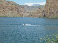
In late August of this year, while visiting friends in Mesa, I had the opportunity to take-in segments of the Salt River Project. There are four Salt River reservoirs, the Theodore Roosevelt Lake, Apache Lake, Canyon Lake and Saguaro Lake with a total storage capacity of about 3.3 maf. Roosevelt Lake is the largest. To give some idea of the size of the project, comparing Salt River reservoir capacity with four Provo River basin reservoirs in Utah, namely Strawberry, Jordanelle, Deer Creek and Utah Lake—the Salt River capacity is greater by about 834,000 acre-feet.
I was surprised to see so much storage in the Salt River Project. The river’s mountain watershed (elevation about 1,500 – 8,000 feet) located east and northeast of Phoenix is desert-like and the climate very hot and dry. However, Arizona’s monsoons generate large volumes of water during the late summer months. I can testify to this. Just outside of Kingman, we experienced a monsoon flash flood, which forced us to pull off the highway and wait it out. It was a terrific down-poor obscuring our vision, making it almost impossible to drive. Along the desert gullies and drainage-ways huge volumes of water appeared within minutes. The storm in a very short period produced enormous volumes of water.
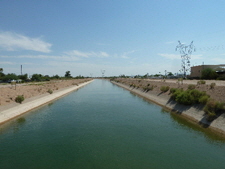
Within the Phoenix metropolitan area there are open irrigation and municipal canals fed by the Salt River Project. Also, the Central Arizona Project Aqueduct conveying water from the Colorado River makes its way through the Phoenix area. Despite, the urbanization of the Phoenix area, there are still large farming operations within the area. Vegetables, lettuce, cotton and hay are the primary crops grown in this region of the state.
|
Two-thirds of Arizona’s population resides within the Phoenix metropolitan area. In 2010 the population was 4.2 million people. Nearly a million people moved into the metropolitan area between 2000 and 2010, making it one of the fastest growing areas in the nation.
Like Utah, Arizona is one the seven basin states that are signatory to the 1922 Colorado River Compact. The Colorado River is critical to the water supply needs of these states, the tribes and Mexico into the future. The river is currently under stress by increasing demand and drought. The problem will only become worse into the future.
Currently, the Bureau of Reclamation is addressing the issue in collaboration with representatives of the seven Colorado River Basin by conducting a "Colorado River Basin Water Supply and Demand Study."
According to the Bureau the scope of the study is: “The study is projected to be complete in November 2012. It will define current and future imbalances in water supply and demand in the Colorado River Basin and the adjacent areas of the Basin States that receive Colorado River water for approximately the next 50 years, and will develop and analyze adaptation and mitigation strategies to resolve those imbalances.”


