A Wonderful Hike to Lake Phoebe-Mary
Beauty and solace just an hour away
LeRoy W. Hooton, Jr.
September 28, 2011
In early September the air is a little cooler, but at over 9,500 feet in elevation the air is always cooler than the temperatures of the Salt Lake Valley at this time of year. School has started
|
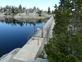
The dam is owned and operated by the Salt Lake City Department of Public Utilities. The lake, when filled to its capacity holds 742 acre-feet of municipal water supply. Constructed between 1913 and 1915, winter snowmelt is stored from the spring run-off for release during the late summer to supplement the normal declining snowmelt flows of the creek. The creek flow is diverted into the Big Cottonwood Water Treatment Plant at the mouth of the canyon for municipal use or allowed to flow downstre
|
The concrete-gravity-constructed dam structure stands 72-feet high and 330-feet long at its crest. It captures water from two natural basins of Lake Phoebe and Lake Mary. The dam costing $50,000 ($1.1 million in 2011 dollars), converted the two lakes into one storage reservoir. It was necessary to construct a channel between the two basins to combine the upper body of water in Lake Mary with Lake Phoebe to equalize the two into one lake. Most of the work was accomplished by the use of horse power and hand tools. Dynamite was used to excavate the overburden to reach bed rock to anchor the dam structure.
Because the construction site was in a remote area (in 1913), it was necessary to establish a construction site to house the workers and their equipment on-site. There was some concern that the construction would ruin the beauty of the area. However, Salt Lake City officials were confident that in time the site would recover “..her prestige as one of the beauty spots of earth.”
The water supply held behind the dam was viewed as critical to Salt Lake City's water supply. City officials expressed this importance, “Nothing on the city's program of improvements is of more vital interest and importance than the storage reservoirs in course of construction at the head of Big Cottonwood Canyon.” It was part of a dam-building program during this period of time consisting of Lake Mary Dam, Twin Lakes Dam in Big Cottonwood Canyon and Mountain Dell Dam in Parley's Canyon.
Up until this dam-building effort, the city only had one storage water dam; the Parley's Canyon Dam located at the mouth of Parley's Canyon. The small dam structure was anchored into Suicide Rock, forming a 1.6 million gallon reservoir. The facility was abandoned in 1953.
Concurrent, with the construction of the Lake Mary Dam was the preliminary design of the Twin Lakes Dam (capacity 934 acre-feet) located west of Lake Mary at about the same elevation. It was under construction by 1915 and completed in 1916. Since their construction, these two structures have provided beneficial water supply to Salt Lake residents for nearly a century.
|
Because of their size and capacity, both dams are rated as “High Hazard Dams.” In 1998, these structures were evaluated to determine their condition and safety. The final engineering reports showed that the structures will continue to provide drinking water supply to Salt Lake City customers into the future. According to Public Utilities engineering administrator Chuck Call, “ There is a lot of weathering on the downstream concrete face, but overall Lake Mary Dam is in great shape.”
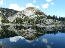
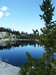
The hike, beginning at the Brighton Ski Lift parking lot takes about 2-1/2 hours, allowing time to enjoy the scenery and have a picnic. Just before reaching Lake Mary, a 500-foot walk takes you to Dog Lake. The area is known for moose sightings; however on the day we took the hike we did not see any. Also, most of the wildflowers had gone dormant. Back on the trail, you first see the downstream face of the dam, then reaching the structure, a short steep hike takes you to the apex and a view of the dam and lake. The view is well worth the hike.
It's not too late to take this great hike and enjoy one of the many jewels of the Wasatch, and see an important part of Salt Lake City's watershed and water supply.
Select Reference
Salt Lake City Municipal Record, September 10, 1914 issue


