Utah Lake and The Jordan River Flood Control
Flood control management of Utah Lake and the Jordan River established by a 1983 lawsuit settlement may be tested this year.
LeRoy W. Hooton, Jr.
June 27, 2011
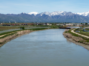
The Surplus Canal near the Salt Lake International Airport is conveying high flows to the Great Salt Lake. Flows have already reached 4,000 cfs.

At the time of this writing, the 2011 spring runoff is still in progress. Going into late May, the potential for flooding was very high. Record snowpack and delayed snowmelt were conditions conducive to severe flooding. However, the cooler weather regime of May has continued into mid-June, allowing a controlled snowmelt, which has moderated the streamflows. It's too early to say we've avoided flooding similar to that we experienced during 1983-85, but high flows have already affected Utah Lake and the Jordan River in conveying the snowmelt to the Great Salt Lake.
It is apparent that this winter's abundant snowpack in the Utah Lake-Jordan River Basin (203 percent of normal) will increase the amount of stored water in Utah Lake and high flows in the Jordan River and Surplus Canal.
The Utah Lake-Jordan River Hydrologic Basin consists of a watershed covering 3,039 square miles including all of Utah and Salt Lake Counties and portions of Wasatch and Juab Counties. The Basin is bounded on the west by the East Tintic Mountains and drains areas as far east as the western slopes of the Uinta Mountains. Most of the water inflow into the lake comes from the Spanish Fork, Provo and American Fork rivers. There are also transbasin diversions from the Weber and Duchesne Basins under the Provo River Project and Colorado River water under the Central Utah Project. The average annual inflow into the lake is 720,000 acre-feet. The average outflow is 346,000 acre-feet, with evaporation accounting for 380,000 acre- feet. The 2011 runoff is projected to be much above average.
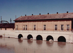
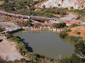
The 50-mile Jordan River conveys water from the Utah Lake watersheds and canyon streams within Salt Lake County watersheds to the Great Salt Lake. The river flows south to north from Utah Lake to the Great Salt Lake. In order to irrigate the valley's benches, it was necessary to make diversions into the various canals at the Jordan Narrows (near the Point of the Mountain) where the elevation was high enough to allow gravity flow. Today, dams situated at or near the Jordan Narrows divert Jordan River water to seven canals (including Salt Lake City's Jordan and Salt Lake Canal) providing irrigation water to Salt Lake and Utah counties' farmland and secondary water systems. During the high runoff period the diversion of Jordan River water into these canals helps reduce the flows in the Jordan River in Salt Lake County.
|
In order to manage high runoff flows along the Jordan River through the populated area of Salt Lake City, in 1885 the Surplus Canal was constructed at 2100 South. The canal flows in a northwesterly direction to the Great Salt Lake. The North Point Canal connects with the Surplus Canal and covers a large area of the level lands lying between Salt Lake City and the lake. Before this year, the record flow conveyed through the Surplus Canal was 3,170 cfs on June 1, 1984.
In the latter part of the nineteenth century conflict arose between Salt Lake and Utah county residents. In 1872 Salt Lake County farmers first constructed a dam near the Jordan Narrows. During the next spring the county court of Utah County asserted that the lake had risen, and the dam was blamed for flooding the farmlands around the lake. It was suggested that the Utah and Salt Lake County Courts meet to resolve the problem. Apparently no resolution was forthcoming, and the dam was washed out for unknown reasons. According to the records of the court of Salt Lake County,"... the head gates washed out, being helped by persons unknown." The issue of a dam in the Jordan River continued to be a point of contention between the two counties. The dam was rebuilt in the spring of 1874. The landowners around the lake continued to complain about the dam, claiming that it was flooding their property. Their complaints were investigated by the county court of Salt Lake, with the finding that the dam had no effect on the elevation of Utah Lake. In 1880, the dam was raised, evoking even more outcry from the Utah County landowners. In 1885, after several years of dispute, an arbitration committee of prominent citizens, led by President John Taylor of the L.D.S. Church, established a compromise elevation of 4,515.799 City datum. The "Compromise Agreement" also provided for the operation of the lake's outlet gates to the Jordan River.
Subsequently, the Utah Lake and Jordan River Commission took over the burden of operations and deciding how the gates would be operated and to what extent they would be opened and closed. The Commission was composed of two members from Salt Lake County, two members from Utah County, and a fifth member who was a referee.
The 1885 "Compromise elevation” held for a century but the heavy precipitation and flooding occurring during the early 1980s changed it. The period between 1983-1985 was the wettest period on record.
On September 15, 1983, the Utah Lake Landowner's Association filed a class action suit. The complaint sought damages and injunctive relief relating to the flooding of lands adjacent to the lake. The plaintiffs alleged a breach of contract based upon the 1885 "Compromise Agreement," by Salt Lake County, the Associated Canal Companies and all others claiming any rights to the waters of Utah Lake.
During 1984, Utah Lake rose some five feet above compromise level, inundating many acres of valuable farm lands around the Lake
|
In 1984, the Legislature discussed the need to address the problem of flooding around Utah Lake and the Jordan River. At that time, $1.5 million was appropriated to the Disaster Relief Board, of which $500,000 was earmarked for engineering studies necessary to alleviate the flooding problems. The studies produced the "Utah Lake Jordan River Flood Management Program" with engineering and construction costing over $10 million.
The construction program consisted of a new outlet structure at Utah Lake, dredging in the lake and the Jordan River and modification to five water control diversion structures. The operation of the lake sought to reduce the lake to compromise level by the end of runoff season, utilization of National Weather Service forecasts for Utah Lake inflow to determine flood releases and to continue the Utah Lake-Jordan River Dam Commission. However, one flood control manager from each county was added to the commission with the State Engineer or other agreed upon third party acting as a tiebreaker.
With the operation plan in place and the construction projects planned, the lawsuit was settled. The parties stipulated on March 8, 1985 that the flood waters in Utah Lake and in the Jordan River shall be managed solely pursuant to the "Utah Lake and Jordan River Operating Procedures and Flood Management Plan," rather than the 1885 Compromise Agreement; and that the flow in the Jordan River would not exceed 3,400 cubic feet per second measured at 2100 South. The new compromise elevation of 4489.0455 above sea level (USGS Survey datum) was established in 1985. When the lake is at compromise the storage capacity is 870,000 acre-feet, of which 128,300 acre-feet is inactive storage, occurring at about 9.2 feet below compromise. It further settled the long-standing belief that the Turner Dam was the cause of water backing into Utah Lake and flooding the surrounding property around the lake. The engineering study proved that a natural restriction at "Indian Ford," south of Camp Williams impeded the flow of the Jordan River.
The Plan protects the primary storage rights of Utah Lake, including those of Salt Lake City, the Utah and Salt Lake Canal Company, South Jordan Canal Company, East Jordan Irrigation Company, North Jordan Irrigation Company, Salt Lake County Water Conservancy District, Central Utah Water Conservancy District and Kennecott Utah Copper Corp. It dedicates the first 125,000 acre-feet of active storage capacity in Utah Lake to those who own primary storage rights. The remaining 616,700 acre-feet of active storage in Utah Lake, up to the compromise level, which may be stored in Utah Lake or in upstream reservoirs (subject to call by Utah Lake water rights), to be used to supply the annual diversion requirements of both primary and secondary storage rights. Once the inflow into the lake reached the new compromise level, the outlet gates are to be opened to allow the free flow of water from the lake. The lawsuit settlement also provides that once the flow reaches 3,400 cfs at the Surplus Canal, the gates regulating the flow out of Utah Lake can be regulated to the Jordan River. The then excess inflow water will be stored in the lake.
The magnitude of this year's runoff is not for certain. There is still copious snow in the watersheds. For example on June 18, Trial Lake's SNOTEL still measures 35-inches of Water Snow Equivalent (SWE), which will continue to provide snowmelt to the Provo River and Utah Lake during the next month. The Snowbird SNOTEL measures 54-inches of SWE. Under normal conditions, at this time of year most of the snow would be already melted, so the extended runoff period will continue to keep water managers on alert well into the early summer months. The flow rate at the Surplus Canal in Salt Lake City has reached 4,000 cfs, 600 cfs above the maximum allowed under the lawsuit settlement agreement. Depending on weather conditions and temperatures, the storage in Utah Lake above compromise (now 2.15 feet above compromise) and flows in the Jordan River (have reached 4,000 cfs) may still reach new record values.

