2011 Spring Runoff - A Record Water Year?
High snowpack and delayed snowmelt raise the specter of potential flooding in Utah.
LeRoy W. Hooton, Jr
May 31, 2011
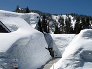
Snow engulfs a cabin in located in Brighton, Big Cottonwood Canyon, Utah.

Under the influence of a strong La Niña in the Pacific Ocean, this past winter’s storms have produced copious snow fall in the West. >From the Sierra Nevadas to the Rockies higher than normal snowpacks are near, or at record levels, raising concerns about flooding during the spring runoff period. The high snowpack, exacerbated by a delayed snowmelt have raised the specter of another 1983 flood scenario in many of the sub-basins of the region.
As of May 1, the Sierra Nevadas have received over 61 feet of snow depth containing a Snow Water Equivalent (SWE) that is 165 percent of normal, breaking the drought that has gripped California over the past several years. Based on this, Governor Jerry Brown has repealed the drought emergency declaration made in 2008. This year's snow fall most likely will surpass the record amount recorded in 1950-51 when 65 feet fell.
Above average snowpack in the Colorado River Basin has prompted the U.S. Bureau of Reclamation (USBR) to begin releasing water from Flaming Gorge reservoir on the Green River and Lake Powell reservoir on the main stem of the Colorado River. According to USBR representative Ed Vidmar, the projected flows on the Yampa River in the Upper Green Basin are expected to be 6 to 10 feet above historic peak levels, resulting in the need to vacate additional space in Flaming Gorge reservoir. Likewise, the above normal snowpack and projected runoff of 11.5 MAF has allowed the USBR to release additional water from Lake Powell to Lake Mead. Lake Powell's level is projected to rise 25 feet this year.
On May 9, the Utah Water Users Association held its final briefing with federal officials regarding the current snowpack and runoff forecast. Natural Resource Conservation Service (NRCS) snow survey supervisor Randy Julander told the assembled water managers that the snowpack in northern Utah is above 1983 levels. With already saturated soils, Julander said that the state has a “phenomenal snowpack and a fantastic water year.”
The current Utah snowpack and resulting projected runoff are well above normal. According to the NRCS's May 2011 Utah Water Supply Outlook Report, the snowpack contains record high SWE as measured by their SNOTEL system in many of the northern basins of the state. The Bear River, Weber and Provo basins are all over 200 percent of average; and the Uintah basin at 172 percent of average is near record. The statewide SWE is near record at 183 percent of average.
The snowpack SWE in the Provo River basin is 203 percent of average. The snowmelt from the Provo River basin flows into Utah Lake and then into the Jordan River through Salt Lake County. The flow in the Jordan River is reduced at 2100 South by diverting approximately 75 percent of the high flows into the Surplus Canal were then both continue northward to the Great Salt Lake. In anticipation of high runoff flows, Jordanelle reservoir has been drawn down to make available over 100,000 acre-feet of space to manage the runoff. Utah Lake is full and the outlet gates are opened allowing free flow into the Jordan River. High flows on the Jordan River are projected for the next several months.
|
Locally, the forecast for the six creeks located along eastern Salt Lake County is for above average runoff. According to National Weather Service hydrologist Brian McInerney, the volume of waters flowing from these creeks is predicted to be 191 percent of average. The Cottonwood creeks are expected to peak at 800 cubic feet per second (cfs), however, there could be problems passing the instantaneous peak flows of these creeks. City Creek is forecast to peak at 210 cfs. “There could be a problem, depending on how much wiggle room (the City) has in their underground pipes,” said McInerney. He noted that there had already been some flooding on Emigration Creek in April caused by a rain event. Available water storage in Little Dell reservoir in Parley's Canyon will prevent flood flows from this drainage.
This year's spring runoff is not typical. Wet and cool weather during April and May has delayed the snowmelt and runoff. According to McInerney, the average temperature at the Salt Lake City International Airport during April was 4.5 degrees below normal and precipitation was 200 percent above normal. This weather pattern has continued through May with wetter and cooler weather conditions. There is still a tremendous amount of snow in the mountains and a shorter period of time in which to get it out before summer-like temperatures arrive. Last year, even with a below average snowpack, there was flooding on Little Cottonwood creek because of a late snowmelt. There is much more snow this year and again with a delayed snowmelt there is a strong possibility of flood flows.
At the time of this writing, we are on the threshold of the high elevation snowmelt and runoff. It's still too early to say that there will be widespread flooding. “We will most likely have some flooding, whether it's catastrophic or minor will depend on how it comes out,” said McInerney.
|
The activities of the Department of Public Utilities in coping with the high flows are provided by Deputy Director Thomas Ward:
With continued wet weather patterns and warming temperatures, the Department continues to closely monitor water conditions in City canyons and local drainage ways.
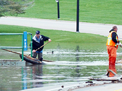
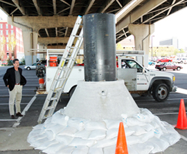
City storm drainage crews, under the leadership of Kelly Brown, have been busy monitoring and managing the near bankful flows of Red Butte Creek, Emigration Creek and Parleys Creek over the past few weeks. Their diligence keeping grates clean from the sizable debris flows, and experience in creative management of high flows, has limited overbank water excursions. City Creek has yet to peak, with peak flows from snowmelt runoff currently forecast for early June by the weather service. Several City staff and work groups have been working with Kelly Brown and Director Jeff Niermeyer to plan for and be prepared to install temporary measures to increase the capacity of the City’s North Temple storm drain system if needed. This has included support for Kelly Brown, Bill Meske, Brett Schuurman, Bernard Mo and others as they work with the UTA light rail contractor and Salt Lake County flood control to identify and prepare strategies to move any extra water from the North Temple corridor to the Jordan River. Provisions include potential need to install the infamous “rocket cones” used to pressurize the North Temple conduit, as well as having sufficient pumps, pipe, sandbags and other materials ready and on hand should the City Creek flows require.
Like all our utility services, the general public is often unaware of the work we do 24 hours a day, 7 days a week to protect the public health and safety. Director Jeff Niermeyer makes it his regular practice to share his appreciation of Public Utilities dedicated staff with the Mayor, City Council and public for their tireless service to the customers of Salt Lake City.

