Water and Nation Building
The Erie Canal contributed to building a nation from sea to shining sea; between the Atlantic and Pacific Ocean
November 25, 2011
LeRoy W. Hooton, Jr.
Historically, water has played a major role in the process of nation building the United States. In the mid-19th and 20th centuries irrigation practiced by the Mormon Pioneers and later federal reclamation projects provided population and agricultural economic growth in the 14 western states located west of the 100th meridian. During the 20th century water supply, flood control and power generation from large dams constructed on the Sacramento, Columbia and Colorado Rivers contributed to national prosperity and winning WWII. The Army Corp of Engineers constructed the TVA, providing water transportation systems, public electricity and controlled flood waters in the Tennessee valley. Large aqueducts carry municipal and industrial water to communities across the nation. All of these have contributed to the building of this nation. However, in 1825, the Erie Canal was the first water project to contribute to the building of this then infant nation.
The Erie Canal
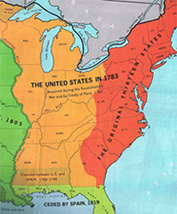
President Washington was concerned that the new frontier shaded in gold color would grow apart from the Original Thirteen States.

Divided by the formidable barricade of the Appalachian Mountains, the Erie Canal facilitated the unification of the Original Thirteen States with the western frontier in the northern region of North America. The western frontier became part of the United States in 1783 as a result of the Revolutionary War and the Treaty of Paris, which included all of the lands located east of the Mississippi River to the western boundary of the Original Thirteen States. Today the states of Wisconsin, Michigan, Illinois, Indiana, Ohio, Kentucky, Tennessee, Mississippi, Alabama and part of Georgia lie within these boundaries.
Unifying the nation was foremost in the mind of the nation's first President George Washington (1789-1797). He was concerned that the population migrating west of the Appalachian Mountains would become foreign to the Original Thirteen States. His worst fear was that they might break away from the Atlantic states and form their own nation – or even worse, join with the Spaniards, the French or the English Canadians who still controlled most of North America, thus limiting the size and might of the United States. It was his hope that canals would bind the two regions together through common interests, mutual interdependence and commerce.
Besides being the Commander in Chief of the Continental Army during the Revolutionary War and the nation's first President, Washington was also a skilled surveyor and understood the geography of the region and the need to overcome the barrier presented by the Appalachian Mountains to the coastal states. Binding the frontier to the Atlantic communities would vex Washington during his Presidency. This was summed up in his 1796 Farewell Address, when he stressed the importance of preserving the Union as a whole: North and South and East and West regions, with emphasis on the West. He averred, “The West derives from the East supplies requisite to its growth and comfort ... and it must by necessity owe the secure enjoyment of indispensable outlets for its own productions to the weight, influence, and the future maritime strength of the Atlantic side of the Union, directed by an indissoluble community of interest as one nation.” Washington believed that canals would provide the means of accomplishing this common interest by connecting the two regions with waterways.
Washington supported the Erie Canal; but didn't live long enough to see it built. However, he was directly involved in the pursuit of an inland navigation system on the Potomac River. In 1784, he formed the Potomac Canal Company to construct a canal around the Great and Little Falls on the Potomac. The canal was completed in 1802, three years after his death. Later two other canals were constructed around the falls above and below Harpers Ferry, West Virginia. The company went bankrupt in 1819.
|
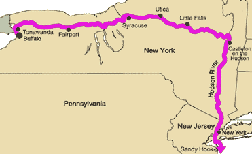
The alignment for the Erie Canal connecting the Great Lakes to the Hudson River was first proposed in 1724 when Cadwallader Colden was hired by William Burnet, the governor of the Province of New York to survey a route for a canal. For nearly a century interest in constructing this canal would rise and fall until 1817, when Governor Dewitt Clinton gained approval by the New York Legislature to construct the Erie Canal. The 364-mile man-made waterway was 42 feet wide and a minimum depth of 4 feet. A series of locks lifted the boats over a total rise of 500 feet on the east-west journey and lowered them on the return trip. Horses and mules on a towpath, urged on by drivers would pull the boats through the canal's water.
The commercial benefits of the canal were manifold. Because a horse could pull fifty times as much in still water over the weight it could carry over a road, freight rates dropped from $100 a ton to $5 to $10 a ton. Travel time was reduced from 26 days to 6 days. This increase in efficiency fostered commerce and human transportation to and from the frontier.
On October 26, 1825, led by Governor Clinton the nation celebrated the completion of the Erie Canal. A line of boats drawn by horses departed from Buffalo on their journey to the Hudson River at Albany. Cannons spaced at twelve mile intervals along the length of the canal boomed, marking the progress of the official procession of canal boats as they traveled from Lake Erie to Albany; and then in steamboats down the Hudson River to New York City. Thus, the interior frontier region of North American was united with Atlantic seaboard of the United States. The canal would make New York the nation's gateway to the West, doubling its population within 10-years after opening the canal for commerce.
|
Along the banks of the canal cities sprung up – among them Utica, Syracuse and Rochester. Furthermore, with the success of the Erie Canal an era of canal building was ushered in that lasted over a decade, until 1837, when an economic recession curtailed investments in canal construction. When the recession ended, other means of transportation had gained favor, and the era of canal building ended.
During the canal building era more than 3,000 miles of canals were built in the northern part of the nation, spurring the growth of a national market economy and binding the western frontier to the Original Thirteen States. This fact was symbolized when New York Governor Clinton celebrated the completion of the Erie Canal by pouring a keg of water taken from Lake Erie into the Atlantic Ocean.
The Erie Canal was then the longest one in the world and considered one of the great wonders of the world. It was a giant step forward in the effort to build a nation from sea to shining sea; between the Atlantic and the Pacific Oceans.
Select References
Rise of the American Nation, Todd Curti
History of Public Works in the United States, American Public Works Association
The Wedding of the Waters, Peter L. Bernstein

