Rainbow Bridge National Monument
This year, the National Park Service celebrates the Rainbow Bridge Centennial.
LeRoy W. Hooton, Jr.
July 22, 2010
In the fall of 1982, my family rented a house boat to cruise Lake Powell. Many years have passed since this occasion, but two lasting impressions have lingered in my mind – the clarity of the night's sky and the brightness of the stars; and especially the spectacular view of Rainbow Bridge.
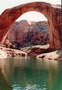
Rainbow Bridge is one of the planet's largest natural bridges formed by the energy of water. It has a span of 234 feet and a height of 290 feet. At the top, the bridge is 42 feet thick and 33 feet wide. The bridge is a religious and sacred site for the Native American Nations and visitors are asked to respect the sanctity of the site.
|
Since its initial filling beginning in March 1963, Lake Powell's water level has fluctuated, mirroring the weather patterns and runoff volumes of the Colorado River. During our cruise, the water level of Lake Powell was at an elevation of 3,687 (USGS) feet, near the lake's full pool elevation of 3,700 feet with a capacity of 25 MAF. The following year the lake would peak 8 feet above the normal maximum elevation reaching 3,708 feet when the Colorado River experienced near record high flows of 180 percent of normal for the water year. This made it necessary to release damaging flows from Lake Powell to the downstream river system. During the wet years of the 1980s, there was concern over the effects of the lake on Rainbow Bridge, but nothing materialized. Beginning in 1999, the Colorado River Basin would enter a decade-long drought cycle, causing the water level in the lake to decline. The U.S. Bureau of Reclamation has described the drought as the most severe in a century. The lake's lowest point was reached in March 2005, when the water level precipitously dropped over 150 feet, leaving a visible bath tub ring on the exposed sandstone. Although not yet fully recovered from the drought, water levels have risen. On July 14, 2010 the elevation was 3,638 feet, filling about 2/3rds of the lake's capacity.
In 1982, the Rainbow Bridge boat dock was a short walk, taking only minutes for one to reach the bridge. The water level was just feet from the base of the bridge. At the current lake elevation it takes a 2.5 mile round-trip hike to reach the bridge from the boat dock location.
Measures have been taken to help stabilize the water level in Lake Powell during drought periods. On December 13, 2007 the seven Colorado River Basin states, Interior and the Bureau of Reclamation signed the Colorado River Shortage Agreement. The Agreement provides among other things, criteria for operating Lake Powell and Lake Mead in tandem during drought periods. The Agreement also provides a means to encourage augmentation and conservation of water supplies on the Colorado River.
Due to the bridge's value as a “scientific example of eccentric stream erosion” on May 30, 1909, President William Howard Taft signed a proclamation designating a 160-acre Rainbow Bridge National Monument. Three years later, then past conservationist President Teddy Roosevelt, along with author Zane Grey visited the monument, adding to its notoriety. Today, with access to the bridge by Lake Powell, annual visitation amounts to about 100,000 people.
The monument is within the Glen Canyon National Recreation Area, and administered by the National Park Service. Paiute and Navajos now share stewardship over what the Navajo's call the “rainbow turned to stone.”
The bridge is accessible by a two hour boat trip from Wahweap Marina near Page, Arizona and Bullfog Marina in Utah and overland by hiking 18 miles after acquiring a permit from the Navajo Nation located in Window Rock, Arizona.
This year, the National Park Service and its partners are sponsoring events to celebrate this natural wonder's centennial. Planned events can be found on their web page.
I still have fond memories of that time in the past when my family enjoyed, among other amenities, the bright heavens at night and the splendor of Rainbow Bridge here on earth.
Related Information: Glen Canyon Dam, forming Lake Powell firms-up Utah and other Upper Basin states' (Utah, Colorado, New Mexico and Wyoming) share of Colorado River water apportionments under the 1922 Colorado River Compact. Under the Compact, the Lower Basin States (Nevada, Arizona and California) are guaranteed an annual 7.5 MAF of water from the river. Water stored in Lake Powell improves the odds that during drought periods, the Upper Basin States will receive their full apportionment after fulfilling the compact requirements to the Lower Basin states. Despite the current drought, the Bureau of Reclamation reports that they have met all of the delivery demands on the river. Salt Lake City receives Colorado River water from the Metropolitan Water District of Salt Lake & Sandy under the Provo River Project and Bonneville Unit of the Central Utah Project
