Old Essays Champion the Geographical Beauty of the Salt Lake Valley
Posted February 22, 2010
Introduction
|
In 1922, a number of essays written by students attending Jordan Junior High School (located at about 1200 West 600 South) were published in the Salt Lake City Municipal Record. The student's written observations of the valley's geographical features were made when most of the valley floor was agrarian and uncluttered with man-made structures. In the intervening years the school has been razed, urbanization has spread over the valley and the culture changed.
These essays give us a glimpse of a time 88 years ago when the Salt Lake valley was mostly farmland and on the threshold of meeting its destiny as a major population center in the Intermountain West. Fortunately, the valley’s physical geographic features provide a lasting view of this unique region of the United States allowing today’s beholders to view and appreciate their wonder and beauty.
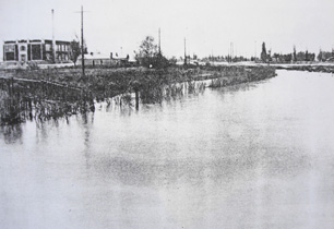
History of the Jordan River
By Alice Willey and Winfield Connon
Along, long time ago, before there were any white man or Indians here, these valleys were entirely covered with a deep inland sea known as Lake Bonneville. For a long period the level of this great lake rose and fell and at last drained so low that it left a lake in Utah Valley and one in Salt Lake Valley.
Before Lake Bonneville had settled, it had formed a great gravel and sand bar at about the dividing line between the two valleys. As the water level lowered the lake in Utah Valley, being higher than that one in Salt Lake Valley, formed an outlet by cutting a channel through this bar. The channel became deeper and wider, and the water level kept lowering until it reached its present level. The channel of the upper lake to the lower one gradually changed its course, from year to year, and became more winding.
Before the white man came here the Indians frequently cross this river and probably camped on its banks. When the Catholic fathers came to visit the Indians in this region they perhaps saw the river. Without doubt the traders, trappers, and explorers knew of the river and its general course.
When the Pioneers first gazed on the river, clumps of willows here and there marked its winding course. Even the pioneer, it is said, rolled his wagon and sometimes pitched his tent along the murky stream. Although the water was not good for the pioneers' use, the oxen quenched their thirst and cooled their feet in its swirling eddies. Along its banks the pioneers found it cooler in the summer and warmer in winter.
It did not get the name it now bears until the pioneers of 1847 came here. Only a day or two after they arrived in the valley an expedition was sent out to explore along the river and the country near by. They bathed in the river's waters and wash their dusty clothes.
When they found this river so similar in its connection to the River Jordan in Palestine which also flowed from a fresh water lake, they decide to give it the same name.
Later some of the most fertile farms were developed along its winding course, at places where the soil was free from alkali and clay.
The waters of the Jordan, in the summer time, irrigate many farms, and the mountain streams feed it. Since early times, the Jordan River has helped to build up this country by supplying it with water for irrigation and power for flour mills.
|
Thrifty farmers have taken canals out on the east and the west side of the river for irrigating. Although it is good for irrigation it is not good or used for household purposes, for the water from the canyon streams are used for irrigation, but it is quiet out of the way, while the “Jordan” is quite near at hand. Because of this they use the “Jordan” to irrigate, for it carries much fertilizer with it, and is warmer, thus making it better for irrigation.
Great Salt Lake and Utah Lake have also been of great use to Utah. Great Salt Lake is the only lake in the United States that provides salt for such a large number of people. It produces salt used all over Utah and much is shipped to other states nearby.
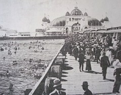
Saltair is one of the greatest bathing resorts in the United States. The fact that the water is so salty that it will hold a person up is one of the reasons why many tourists come to see Salt Lake City and its surrounding points of interest.
Utah Lake is also a great pleasure resort and a financial asset to the people of the cities near to it. Although Utah Lake is not as widely known as Great Salt Lake, nevertheless, it furnishes pleasure to all who seek it.
Taken all in all the Jordan River is a great asset to the city and the state.
Autobiography of the Jordan
By Jennie Holden
My story begins when the greater part of the old Lake Bonneville found its way through the Bear River to the Snake River and from there to the Columbia River into the ocean. Of all this vast expanse of water two lakes, one a fresh water lake, the other a salt water lake were left. It served as the outlet for the fresh water lake and the inlet for the salt water lake. The country around me was an uninhabited wilderness, except for the Indians, until one day a Spanish Priest, Father Escalante camped on my shores to civilize the Indians and to teach them how to farm.
A very long time passed before another incident happened which is worth while to relate. A French fur trader by the name of Provost, established a fur trading post on my banks. Several Indians came later bringing hides and pelts of animals to trade for articles.
As the years rolled on and people gradually began to move into the valley I became known as the Jordan River. For a few years my only duties were to keep the outlet open from Utah Lake to Great Salt Lake, but later on my waters were used for irrigation by farmers who lived near my course. Dams were built to keep back my waters for this purpose while small pumping stations were used for the truck gardens. Later on as settlements began to increase along my course, and manufacturing began to thrive, the city began to use my course as a dumping ground for refuse and rubbish, but the citizens around my banks complained and it was stopped.
To create a larger interest on the west side of Salt Lake City, to beautify to still greater extent my natural beauty, and to try to make my course a benefit to the citizens of Salt Lake City are the main reasons why I have told my own story.
Our Mountains
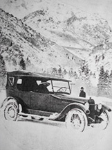
Motor touring in Big Cottonwood Canyon.
By Fay Cochran
As we stand beside the Jordan Junior High School gazing east at the beautiful majestic, snow-clad peaks of the Wasatch Mountains, we get an inspiration that no pen can describe, of wonderous [sic] peaks which reach into the very clouds. The early pioneers who came through the same mountains into this valley when it was a wilderness must have had the same inspiration.
Sometimes when the sun shines brilliantly upon them they look like sparkling crystal, and yet sometimes when dark clouds of vapor rest around them they can hardly be seen. These mountains are of various types, those of the sky scraping nature are perpetually snow-capped while the lower ones are rolling and pine-clad, decorated with many hued flowers and leafy shrubs. These lofty heights are seamed with deep canyons through which run streams of water, cold as ice.
City Creek Canyon, on the north, is only five minutes ride from the heart of the city. It has a beautiful winding road and many grand waterfalls. The great scenic boulevard follows one of the mountain side terraces of old Lake Bonneville and links together the canyons of Salt Lake City. Emigration Canyon, through which the Pioneers first entered the valley, has rugged ravines bedecked with innumerable flowers. It has a wonderful fragrance of mountain pine, icy water and luring trails. Parley's Canyon is
|
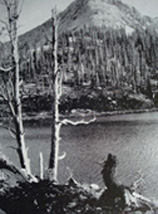
Brighton is at the head of Big Cottonwood and I think the most beautiful of all. Here, deep lakes are set in rugged mountains and winding trails turned in and out. Gigantic rocks form buttresses to the front of the land and just off the main road which circles this Silver Lake Resort. Radiantly hued blossoms flower abundantly there, while all around our stately pines and quaking aspens.
Our other range of this picturesque mountains are the Oquirrh, situated west of Salt Lake City, but they have not the grandeur and height of the Wasatch Mountains. The scenic splendor of the setting sun throwing its rays of rainbow colors upon the mountains is a beautiful site to behold.
Our school is situated in the very heart of the wonderful valley and we are surrounded on all sides by these grand mountains of which we proudly boast.


