Lake Bonneville – The Predecessor of the Great Salt Lake
Thousands of years ago, the natural dam containing Lake Bonneville failed resulting in a catastrophic flood on the Snake River; today the remnant Great Salt Lake, and the Snake River are prominent natural geological landmarks of the Intermountain West.
LeRoy W. Hooton, Jr.
September 24, 2010
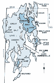
Lake Bonneville and the smaller Great Salt Lake. Map by the Utah Geological Survey.

The Great Salt Lake, located in northern Utah extends 75 miles northward towards the Utah-Idaho border and is 40 miles wide, straddling the Wasatch Mountains and the Great Basin desert. It covers about 2,100 square miles, and contains 28 million acre-feet of saline water at a surface elevation of 4,210 feet. It’s curious that this inland sea exists in Utah, the second driest state in the Union. However, to understand the origin of the Great Salt Lake, it's necessary to look at the region's geological history going back thousands of years ago.
The Great Salt Lake is a product of historic Lake Bonneville that dates back to the Pleistocene period (about 70,000 years ago) during the last ice age. Lake Bonneville occupied 20,000 square miles of area from Milford, Utah, to Malad, Idaho, and held 10 times the current water content of the Great Salt Lake, or the amount of water contained in Lake Michigan. The end of Lake Bonneville and the beginning of the Great Salt Lake began with a breach of Lake Bonneville's containment, causing a catastrophic flood on the Snake River and reducing the water volume in the ancient lake.
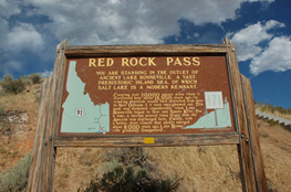
According to the Utah Geological Survey, Lake Bonneville's elevation at its highest point at Red Rock Pass was nearly 1,000 feet higher than the present level of the Great Salt Lake. Red Rock Pass is located on the far northern shore of Lake Bonneville, north of Preston, Idaho. At the end of the ice age, the earth's climate began warming, which increased the glacier ice-melt flows into this terminal lake. Scientists believe that between 15,000 to 20,000 years ago these flows feeding into the Bear River overfilled the lake, causing a breach of the natural dam at Red Rock Pass. This breach resulted in a flood surge estimated to be 300 to 400 feet high cascading down-gradient through the present Marsh Valley and Portneuf River to the Snake River near Pocatello, then continuing on to the Columbia River and finally discharging into the Pacific Ocean. The flood has been described by retired BLM District Geologist Lawrence Dee, as one of the greatest floods known in the history of the world.
|
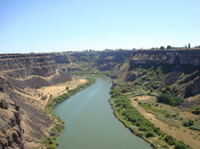
The breach caused the lake to rapidly drain with the surface level dropping approximately 300 feet within days. Over the next 600 years it continued to decline, stabilizing at the elevation of the Salt Lake and Provo shorelines. The evidence of this is still visible on the benches of the Wasatch Mountains at about the 5,100 foot elevation. The breach produced catastrophic water flow volumes. According to Harold Malde (1968) of the USGS, the probable peak discharge of the flood was approximately 15 million cubic feet per second. Malde further suggests that the flood's huge surge lasted for several days on the Snake River with sustained high flows continuing for about one-year. Downstream, the flood surge completely filled Snake River Canyon near Twin Falls and in some locations it overflowed the 500-foot deep canyon.
Over the subsequent eons, the processes of climate change and evaporation have reduced the once enormous Bonneville Lake to three smaller lakes; the Great Salt Lake, Utah Lake and Sevier Lake.
In modern times the Great Salt Lake has provided enormous benefits for the citizens of Utah; and the Snake River is a critical water resource for the residents of Idaho and other downstream users.
The Great Salt Lake and surrounding shores support wildlife, recreation and mineral production activities. It is estimated that three million birds migrate through the area to the south. Mineral extraction from the lake includes common salt, salt cakes, sulfate of potash (fertilizer), and magnesium chloride. Sail boating is a popular recreational use of the lake. In recent years, harvesting brine flies for fertilizer has grown as a commercial endeavor.
The water flowing in the Snake River provides Idaho a thriving agriculture economy. Three million acres of farmland on the Snake River Plain are irrigated from water diverted from the river and conveyed in large canals and ground water wells. Besides agriculture, the Snake River has become a tourist attraction. Daredevil Evil Knievel's failed 1974 rocket powered sky cycle jump made the Snake River Canyon famous. The remnant of the launching ramp is still visible. The Twin Falls bridge is a popular base site for skydivers and bungee jumpers.
|
Due to its salinity, the Great Salt Lake water is not used directly for water supply, nevertheless the lake does make a major contribution to the Wasatch Front's water supply through the phenomenon of “the lake effect” on the region's winter snowpack. The phenomenon is produced when cold storm winds flow over the warmer Great Salt Lake waters, which provides energy to pick up water vapor that freezes and is deposited as snow on the leeward shores. This process is enhanced with the wind-lift of the Wasatch Mountains. This condition produces additional snowfall amounts, increasing the volumes of run-off from the mountain watersheds used for municipal drinking water and agricultural irrigation supplies. Despite being situated on the edge of the Great Basin desert, the Wasatch Canyons are known for their snow depths and the ski business exhort the quality and quantity of the snow for skiing, which in part is attributed to the “lake effect” of the Great Salt Lake.
It's difficult to fully comprehend the forces of nature that occurred thousands of years ago. The breach of the natural dam at Red Rock Pass and the resulting flood are events of such magnitude we can only wonder about, but do point out the enormous forces that have shaped our environs.
Select References:
Utah Geological Survey: Utah’s hydrological cycle
USGS: Lake Bonneville and the Bonneville Flood
Red Rock Pass: site visit
Twin Falls Visitor’s Center: The Natural History of the Snake River Canyon, Lawrence Dee, Geologist

