The Wonder of Glaciers
North to Alaska reveals a world of water and untamed nature
LeRoy W. Hooton, Jr.
September 22, 2009
|
Glaciers are second to oceans as reservoirs of water; and the largest reservoirs of fresh water on the globe. They are found in the Polar Regions and high mountain ranges on every continent, except Australia. Only 2.5 percent of Earth's water is fresh, of which 70 percent is frozen in the polar ice sheets and glaciers, leaving less than one percent for human uses. The last “Ice Age” or more correctly “Glacier Age” peaked about 20,000 years ago when extensive ice sheets covered the North American and Eurasian continents. Glaciers are categorized as: 1) Continental ice sheets that are present in the Antarctica and Greenland, 2) Alpine glaciers that form on mountain slopes and 3) Tidewater glaciers that terminate in the sea.
The Glacier Age extended as far south to affect Utah's higher elevations 10,000 to 30,000 years ago. According to the Utah Geological Survey, “Glaciers have covered mountain ranges and high plateaus in Utah at various times in the past...glaciers in Utah disappeared thousands of years ago.”
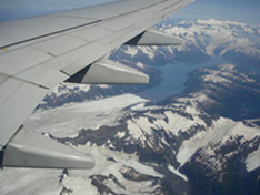
Little did I know that I would be so intrigued with glaciers when my wife and I decided to travel to Alaska in early August. Flying over the coastline in route to Anchorage, I saw my first tidewater glacier, situated south of our destination. Before the trip was over we saw numerous glaciers, including those during our cruise traveling through College Fjord and Glacier Bay National Park and Preserve.
Glaciers are formed in climates where the accumulation of snow forming ice exceeds the rate of melting during the summer months. As tidewater glaciers grow, gravity causes them to move down-gradient to the sea. The rate of movement depends on the surface slope and the weight of the ice mass. The size of the glaciers depends on a balance of ambient temperature, precipitation (snowfall) and topography.
In Whittier, Alaska, we didn't physically see the Whittier and Shakespeare alpine glaciers, but we did see their melting ice flow cascading down the mountain side into Passage Canal Bay. The combined flow was estimated to be several hundred cubic feet per second. This visual provided an idea of the huge volumes of fresh water that are generated from the vast number of glaciers covering the globe.
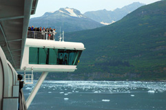
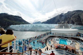
Boarding the Diamond Princes cruise ship in Whittier, we began our seaward adventure in a floating observatory that was 1,000 feet long, rising in height 203 feet above its keel. The adventure included spectacular scenery, marine life and glaciers.
|
Located near Juneau is the 3.3 million acre Glacier Bay National Park and Preserve with the 90-mile long Glacier Bay that contains 12 tidewater glaciers. The bay has an interesting history. First discovered by Captain Vancouver in 1794, the bay was all glacier – 100 miles long, 20 miles wide and a thousand feet thick. But 85 years later in 1879, naturalist John Muir observed that the ice had retreated exposing 5-miles of inlet to the bay. Today the Glacier Bay glacier has receded to the total length of the bay. The Park's official map chronicles the dates in which the bay glaciers have receded northward.
This recorded observation of Glacier Bay may have been the harbinger of the current global warming trend. Over the eons of time, there have been changes to the globe's glaciers – they have expanded and retreated during periodical cooling and heating cycles. A Park Ranger who boarded the cruise ship, noted that two centuries ago there was a phenomenal change in the bay, which is not fully understood. In regards to the explanation of the current glacier retreat, the Park's information brochure reads: “As part of a natural cycle, the bay's glaciers have been retreating for the past 200 years. But even as the earth warms, there are advancing glaciers in the park. So only time will tell how human activities contribute.”
The most spectacular glaciers were the famous Margerie Glacier and located adjacent to it, the Grand Pacific Glacier. Both are located at the northern end of Glacier Bay and are much different in appearance: Margerie is about a mile-wide rising 250 feet from the waterline and is a bright white with a blueish tint, while the International is not as large and is dirty in appearance. Margerie is the most photographed scene in Alaska. The Grand Pacific's color is a result of its geography and the scouring effect of the glacier as it moves down-gradient, causing the accumulation of dirt and rocks that gives it the dirty appearance.
While aboard the cruise ship whales were observed and dolphins could be seen swimming in unison through the sea water. Unfortunately, these sightings were at great distance.
|
I've heard, in what I believed to be hyperbole, the notion of transporting glaciers to the lower western states to relieve water shortages during droughts. However, if not hyperbole, it would be a desperate measure and if successful it would be the greatest undertaking of a water transfer ever known.
Traveling to the Alaska and the Pacific Northwest to view this vast area and its glaciers is a breathtaking experience – one that should be included on everyone's wish list.
Selected references:
The Alaska Cruise Companion, by Joe Upton
Comments of Glacier Bay Nation Park Service Rangers
Glacier Bay, National Park Service, U.S. Department of Interior
Wikipedia, the free encyclopedia


