Do you know what a miner's inch is?
During the early settlement of western America a mining measurement was used for a short time for river, canal and ditch measurements.
By LeRoy W. Hooton, Jr.
August 26,2009
|
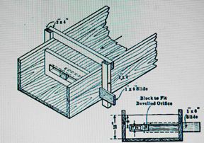
A miner's inch represents the rate of water flow in a miner's sluice through an orifice one inch square, or one-inch in diameter, through a two-inch thick plank with a head of six inches. This single orifice was limited to low flows in the range of 1.5 cubic feet per minute (11.25 gallons per minute). For hydraulic mining the standard orifice is square and the head 4 to 9 inches. This method of measuring flow may have European origins and most likely was introduced in the U.S. during the California Gold Rush years.
The statutory quantity of water represented by a miner's inch varies within the states. In Idaho, Kansas, Nebraska, South and North Dakota, New Mexico, Washington, southern California and Utah a miner's inch equals 0.020 cubic feet per second (cfs). It equals 0.025 cfs in northern Nevada, Arizona, Oregon and Montana. Colorado's unit of measurement is 0.026 cfs.
Water flow data, measured in “miner's inches” do not appear in early records kept by Salt Lake City. The City's water records are expressed in million gallons per day (mgd) and cfs. These units of measurement are interchangeable by using a conversion factor. If the flow is measured in mgd, it can be converted to cfs by multiplying it by 1.547. Or if measured in cfs, the number can be converted to mgd by dividing it by 0.646.
One of the first City recorded flow measurements appeared in the City Council minutes of August 12, 1872. Herman Schussler, Civil & Hydraulic Engineer was hired by the City to design the water system to convey water from City Creek into a piped system to serve the business district. In his report he wrote, “By an approximate gauging I found the creek to deliver in the neighborhood of ten million gallons per diem of 24 hours, which amount is far in excess of the water required.” At that time there were no flow measuring devices on City Creek, so Mr. Schussler must have used his judgment to determine the flow rate.
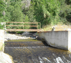
The first measuring device installed in City Creek occurred in 1892. A Cippoletti weir was installed at a location of the old highline diversion into a wooden tank, which would later be the site for the Pleasant Valley Reservoir.
|
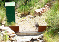
An inventory of measuring devices was contained in the 1906 Annual Report of the City Engineer. In total, 34 weirs were listed measuring the stream flows of City Creek, Emigration, Parley's, Big Cottonwood and Little Cottonwood and 16 irrigation diversion ditches on Big Cottonwood Creek. Two weirs were Rectangular and the remaining 14 were Cippoletti weirs. During that year, the City Engineer reported, “It is important that the City have a record of the flow of water in the different streams which are a possible source of future water supply, as well as in the streams we draw our present supply.” This was sound advice, as during the next thirty years the City would continue to make exchange agreements with the farmers on Mill Creek, Big Cottonwood and Little Cottonwood creeks. It was noted that a weir was installed on Little Cottonwood Creek during the year. The weir was the first measuring device of record on this creek.
By 1909, according to that year's annual report, the number of measuring weirs had increased to 76 including 28 weirs on the Jordan & Salt Lake Canal.
In 1879, the United States Geological Survey (USGS) was formed by Congress. Shortly afterwards, John Wesley Powell was appointed director of the organization. His task was to make a topographic survey of the American West. Later in 1888, Congress amended the task to include identifying potential irrigation projects and reservoir sites on western rivers and streams to pave the way for increasing the population of the West. The federal government had an enormous impact on water resource measurement and engineering.
|
Most likely, during the USGS's early history and particularly in southern California, the miner's inch was used as a means of measuring and recording flow data. However, there is no contemporary indication of this fact on the USGS' web pages. An inquiry was made to Ken Dixon, USGS Alaska Science Center Earth Science Information Center – Anchorage. Mr. Dixon checked USGS records dating back to 1898- 1920 and could not find any data recorded in miner's inches. He wrote “While I never found a Water Supply Paper that used the measurement, I managed to find a bulletin that used the miner's inch in the text from Bulletin 613 dated 1915 entitled, "Guidebook of the Western United States - Part C, The Santa Fe Route.". Mr. Dixon's cursory review of USGS documents indicates that most likely miner's inch measurements were not used after 1898.
In Utah, with statehood in 1896, a year later in 1897, the office of the State Engineer was established. The State Engineer's primary duty then was to measure stream flows, approve plans for dams and supervise state irrigation works. The position's duties were enlarged in 1901 when the State Engineer was given the authority to supervise the distribution of water. Under Utah's administrative rules adopted in 1903 the State Engineer's duties were expanded to include the receipt and approval of applications to appropriate water and to make complete a hydrographic survey of each river system. During this early period, the state quantified the rate of flow of water in cfs, and for volume the unit of acre-feet. In the State Engineer's list of definitions, the term miner's inch is defined as: “an old term for the rate of discharge through an orifice one inch square under a specific head; in Utah, it equals 0.020 cfs.”
It appears that the use of the miner's inch became obsolete early in the history of western America with the evolution of better technologies and hydrological structures capable of accurately measuring water flows ranging from small irrigation diversions to high flood stage stream and river flows. The federal government probably had the greatest influence on water measurement technology and data collection with the USGS and Reclamation Service's extensive surveys of the West's water resources. It appears that the miner's inch method of measurement was limited to a period of the early settlement of the West. However, it did provide a means to quantify early farmers' irrigation rights. This is demonstrated by the fact that 14 states established statutory standards for the miner's inch.
Today, there have been enormous advancements in measuring the nation's water. New technologies now allow real time transmission of stream flow data from over 4,200 gaging stations across the U.S. Much of this information is available via the Internet.


