Snow measurements are critical to water resource management in the west
Millions depend on mountain snowpack for their water supply. Salt Lake City begins snow surveys in 1912.
February 19, 2008
LeRoy W. Hooton, Jr.
|
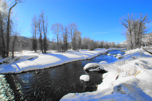
The amount of snow (and water) varies from year to year. The more snow the better the water supply, less snow means less water supply. Extremely high snowpack could cause flooding during the spring run-off (1983) and extremely low snowpack could mean drought (1935) or water-short supplies for the coming year.
Water users watch the snowpack during the winter months in anticipation of having an adequate water supply. Early settlers would visually observe the snow buildup in the mountains as an indication of the amount of run-off water these watersheds would provide for irrigating their fields and crops. As settlements grew into cities and towns municipal water officials likewise kept a watchful eye on the snowcapped mountains. During this period, the rule-of-thumb was that 10 inches of snow produces 1 inch of water. Because of the drier snow in Utah the estimate was 12 inches produces 1 inch of water.
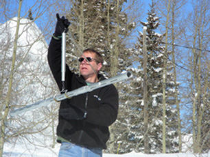
In 1906 University of Nevada – Reno Professor James Church made a major contribution to the science of snow measuring and run-off forecasting . He laid out the first snow course at Mt. Rose in the Sierra Nevada and invented the snow (tube) sampler (Mt. Rose Snow Sampler). Recognizing that snow has varying amounts of water content, Dr. Church found that by measuring the depth of snow and weighing the snow in the tube sampler, he could calculate the snow water equivalent (SWE) and density. This information then allowed him to determine how much water the snow would yield when it melted. He developed a “Density Determination Chart” to calculate the snow density percentage (ratio of water to snow). His contributions to the science of snow sampling and technique were celebrated in 2006 by the USDA and University of Nevada, Reno on the 100th anniversary of his snow sampling on Mt. Rose. (The Grandfather of Snow, time.com/time/magazine/article/0,9171,856960,00.html; and NRCS Snow Survey Centennial Celebration, www.nv.nrcs.usda.gov/news/SnowSurveyCent.html)
In 1898, the first weirs for measuring and recording water flows from the various canyon streams were constructed by Salt Lake City. Stream flows were manually measured twice a day and recorded. (1907 Annual Report of the City Engineer) Subsequently, automatic recording devices were constructed at the weirs to continuously record stream flows. (Municipal Record January 10, 1915)
|
The data generated from the survey was used for forecasting run-off volumes by using the snow course measurements converted to acre-feet (watershed area x SWE) compared to actual volume measurements taken at the City's weir at the mouth of Big Cottonwood Canyon from May to September. For example, in 1912 the snow survey results were used to calculate a run-off of 55,561 acre-feet of water and 52,458 acre-feet was actually measured at the weir. Using this method, similar ratios were determined for 1913, 1914, and 1915 to forecast water run-off, resulting in a 1.14 ratio between the measured snowpack and projected run-off volumes. (Municipal Record 1916)
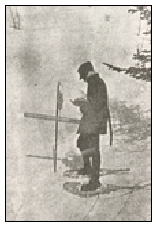
In these early years, the snow surveyors would take up to a week to travel up and back down the canyons and conduct the measurements. Equipment and supplies were carried on sleds pulled by surveyors on snowshoes. “We loaded our tent, bed and supplies on a sled previously made for this purpose, and started up the Canyon (City Creek). The sled was made with a pair of skis as runners, and when loaded with our outfit weighted about 275 pounds,” wrote Weather Bureau assistant surveyor A. A. Justice. In 1915, it took from March 18 – 26 to travel to the head waters of City Creek at an elevation of 8,500 to 9,500 feet and to make 296 measurements over a four square mile area. (Municipal Record 1915)
The trek up Big Cottonwood Canyon was no less laborious. The snow surveyors took a week to complete their work. The team consisted of 5 men, a horse team and skis. They spent two days at Maxfield Lodge located one-half mile up canyon from Storm Mountain where snow measurements at Mill B and Mineral Fork were taken. The horses were left at the lodge and the surveyors continued on skis traveling the 12-miles to Brighton. (1916 Annual Report of the City Engineer)
In the mid-1930s Congress mandated the federal government initiated programs to measure snowpack in the mountains of the western United States and implement programs for hydrological and climatological data collection and management of the natural resources of this region of the nation.
During most of the 20th century snowpack measurements were made by using the snow sampler technology. This method still remains one of the basic tools used for manually measuring SWE.
|
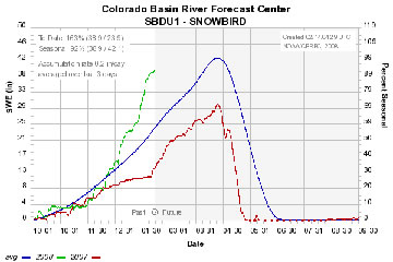
The SNOTEL technology utilizes a pressure sensing snow pillow filled with glycol that measures the weight of the snow resting on it, which then determines the SWE in the snow. Other instruments include a storage precipitation gage, air temperature and soil moisture sensors. This information is transmitted from the remote sites to central computers, where snowpack data is assembled, analyzed and dispersed to water users throughout the West.
The U.S Department of Agriculture (USDA) and the Natural Resources Conservation Service (NRCS) are responsible for installing, operating and maintaining the SNOTEL system and for providing water supply forecasts and flood control data to aid emergency agencies to cope with flood disasters.
According to Natural Resource Conservation Service snow survey manager, Randy Julander, there are over 700 SNOTEL sites in the West with 85 in Utah. Five more are scheduled to be installed in Utah during the next 2 years. The benefits derived from having the system are enormous according to Julander, affecting nearly every aspect of society. “The list is pretty much endless, from recreation to mushroom hunters to irrigation to floods and droughts ... with incredible usage,” says Julander.
In 1922 the snow measurements were transferred from the City Engineer's office to the Water Department (Department of Public Utilities). It is assumed that this was a result of H. K Burton becoming Water Superintendent in 1920 (1920-1947) and facilitating the change in responsibility. Prior to him becoming superintendent, he was responsible for snow
|
Public Utilities Department hydrology specialist Larry Alserda is responsible for measuring and recording snowpack data, stream flow and diversion records for Salt Lake City. He knows the Wasatch Canyons snow conditions like the back of his hand. He continues to measure the old snow courses, where the City has over 86 years of continuous data. “I have found through more than 20 years of experience that you must see each site and become familiar with the unique characteristics of each one,” says Alserda. The deepest snow he has ever measured was 189 inches at Alta, Little Cottonwood Canyon in 1993.
As water supplies become scarcer, water resource management and conservation will become ever more important to the western states. This added with potential impacts of global warming, makes the science of snow more critical to the millions of inhabitants of this region that rely on snowpack for a substantial portion of their water supply.


