|
Utah's Winter Snow
SNOTEL sites measure snowpack
LeRoy W. Hooton, Jr.
February 27, 2004
|
|
|
Snowpack measurements in
the Wasatch Mountains in Salt Lake County capiture large amounts
of snow. Snowbird in Little Cottonwood Canyon receives a SWE
of 42 inches. Brighton located in Big Cottonwood Canyon 27
inches. Snowmelt from these canyons provide drinking water
supply to Salt Lake City's water service area.
|
|
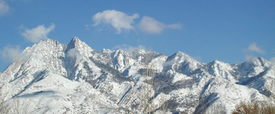
Utah's winter scenic splendor varies from place to place, depending on where
you are viewing it. Most notably, the amount of snow varies
by elevation and geographic location. The northern mountains are covered
with a deep mantle of winter snow, while the farther south you travel the
landscape changes to less snow cover, particularly in the valleys.
Nearly all of the state's high elevation peaks collect snow during the winter
months. This is critically important in the second driest state located
in the continental United States. Moreover, copious high elevation snowpack
melts later in the season and keeps the stream flows higher into the summer
months. Regardless where one resides in the state, this snow provides the
precious water supply for the state's inhabitants.
|
|
|
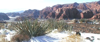
Considerably less snow falls
in southern Utah; however, the higher elevations within the
Virgin River watershed do receive heavy snows.
|
|
The amount of snow the state receives each winter determines how much water
will be available for the coming year. Precipitation can range from low
amounts that create drought conditions and high amounts that create flooding
conditions. Data collected by the United States Department of Agriculture,
Natural Resource Conservation Center (NRCS) over the years has developed
a data base by which NRCS scientists and hydrologists can forecast snowmelt
run-off volumes and their variations from year to year.
The amount of water contained in the snowpack as measured by SNOTEL is
called "Snow Water Equivalent" (SWE) and varies from snow course
to snow course depending on elevation and location within the state. For
example, at elevations ranging from 8,000 to 9200 feet, the SWE varies
from the northern part of the state compared to the southern region, with
declining values as you move southward. Located in the formost
northern part of state in the Bear River Basin, the Tony Grove Lake SNOTEL,
elevation 9600 feet, receives a SWE of 38-inches. In the Weber Basin,
the Monte Cristo SNOTEL, located at the 8960 elevation, on average receives
31 inches of SWE. In the Weber - Ogden River Basins Ben Lomond Peak, located
at the 8000-foot elevation, averages 42 inches. Moving southward
to Snowbird, located at the 9640-foot elevation in Little Cottonwood Canyon,
the average SWE is 42 inches.
|
|
|
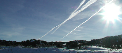
Jet contrails mark the sky
in central Utah along I-15. Weather patterns and lower elevation
mountains result in lower SWE values as you move from the
north to the southern part of the state.
|
|
Moving farther south in the Price-San Rafel drainage, Red Pine Ridge, located
at the 9200-foot elevation, receives an average of 17.5 inches of SWE. In
the Sevier River drainage, the Agua Canyon SNOTEL, located at an elevation
of 8900 feet, receives a scant 8 inches. Water content varies within the
Virgin River drainage as the elevation changes downward into the Great Basin
Desert. Colob, at 9250 feet, receives 24 inches; Long Flat at 8000
feet receives 9 inches, and Little Grassy at 6100 feet near the Nevada border
receives about 6 inches.
According to the data, Ben Lomond and Snowbird, both located in the northern-central
mountains, have the highest SWE values with an average of 42 inches, and
the lowest are Little Grassy and Long Valley Jct. located in the Virgin
River Basin with about 6-inches.
If you want to check out the snowpack data on your computer log on to
National Weather Service - Colorado Basin River Forecast Center at: www.cbrfc.noaa.gov/snow/snow.cgi
For other water related articles go to Salt Lake City Department of Public
Utilities Web Page at: http://www.ci.slc.ut.us/utilities/
|