Storm fine, but drought goes on
By Joe Bauman
Deseret News staff writer
|
Every day without snow is just another stinkin day of sunshine, a rueful Randy Julander said.
Julander, snow survey supervisor for the U.S. Natural Resources Conservation Service in Salt Lake City, was joking, but beneath the jest was a frightening fact.
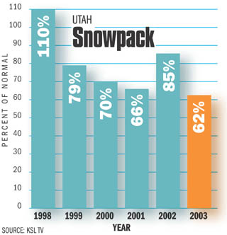
Everyone knows that this is the fifth consecutive year of drought, said Mark Eubank, chief meteorologist at KSL. But the thing thats so discouraging is that this is the worst year of the five.
He provided figures showing that snowpack levels as of early February are only 62 percent of normal, averaged across the state. The first year in the series, 1999, was down to 79 percent. Last year, during which the drought reached crisis proportions, the early February snowpack was at 85 percent of normal.
If you can believe it, it looks like were working our way down to something worse, Eubank said.
The hope is that this springs precipitation will be huge, but the outlook isnt good. According to Eubank, Utah needs normal storms to stay even and super storms to catch up.
And we dont have either coming anytime soon, he said. Predictions drop in reliability the further a scientist peers into the future, and two weeks out starts to push the limits. But looking out that far ahead, no storms are predicted for Utah.
We cant do that. We cant miss two weeks of storminess, Eubank said.
Grant Weyman, his colleague meteorologist at KSL, said everyone is worried about the end of the winter and the spring. We dont want another dry year, he said.
In order to reach an average snowpack by April 1, the usual date for the start of spring run-off, 166 percent of the usual precipitation must fall in Utah during February and March.
The probability of that happening, said Julander, is 3 percent.
The survey supervisor gave this breakdown for the amount of precipitation needed for Utahs drainage basins to reach normal snowpack, along with the chance that will happen:
In some areas, a heavy storm is more likely than in others, or one storm will dump a great proportion of the snow recorded for some arid area. Therefore, the
percentages dont directly link to the level of snow needed.
The measurement station at Trial Lake, which calculates snow on courses
that feed water into the Salt Lake City system, is a good index for this region, Julander said. Sundays storm was a significant event, but it would take between
25 to 28 storms of that size to bring that site back to normal, he said.
For the rest of February and March, he said, a good storm every two to three days is what youd have to have...
And the probability of that happening is very remote. With average precipitation instead, the accumulation should end up in the range of 60 percent to 75 percent.
Meanwhile, for the most part, reservoir storage across the state is poor. An exception is the Central Utah Projects Strawberry Reservoir, but the Diamond
Fork diversion system isnt ready to deliver water.
Everywhere else you take a look at reservoir storage and you shake your
head, Julander said. Oh my goodness. Hope it doesnt go on any longer.
E-MAIL: bau@desnews.com