The Perfect Storm
After a long hot and dry summer and fall, the snow begins to fall.
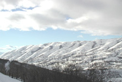
December 4, 2001
|
But it only got better. By December 4, 2001 Snowbird increased nearly another 3 inches, Brighton another inch, Parleys Summit 1.6 inches and Trial Lake 1.7 inches. Ben Lomond Peak gained another 6 inches for a total of 10.4 inches. On November 21, Ben Lomond Peak was zero. (See table below)
On November 26, the Trial Lake (9960 ft.) SnowTel station measured 4.2 inches of water, 86 percent of normal for this time of year. Trial Lake is a key indicator of the water supply for the Provo, Weber and Duchesne drainages. Last year lower than normal snowpack at this measuring station was the harbinger of lower than normal run-off and reduced stored water in Deer Creek Reservoir, a major source of water to Salt Lake County. Key to turning around the drought is replenishing this reservoir next spring.
Continued snowstorms during the following week, increased the snowpack and water content. Snowbirds water content rose to 9.0 inches by November 30. The rapid build up of snowpack experienced by all of the local ski resorts has drawn skiers to feast on the mountainsides. Before the storms, the Utah Lake drainage average was 7 percent of normal, today its 113 percent, snow survey supervisor Randy Julander, told a group of water professionals attending the Utah Summit conference held in Salt Lake City. This single storm system amounted to about 15 percent of our annual snow it was a heck of a storm. Julander noted that the state as a whole was about normal.
Are we out of the drought? Its too early to tell. Even if the snow pack continues to build at normal or above normal levels, low soil moisture and reservoir levels carried over from the previous water year may determine how much water is available next summer. Current reservoir storage in the Bear River drainage is about 40 percent, Weber drainage about 30 percent an
|
According to Julander there are no clear indicators to predict what kind of weather the state will experience for the remaining winter months. "The data is inclusive, in other words we are clueless," quiped Julander.