 |
|
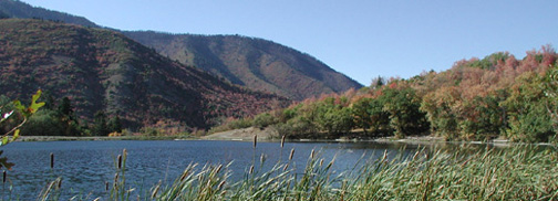
Maple Lake located in Payson Canyon, Utah |
Autumn Water
Fall colors adorn Utah's streams and reservoirs, but drought conditions affect storage levels in the northern part of the state.
LeRoy W. Hooton, Jr.
October 5, 2001
Streams, lakes and reservoirs across the state of Utah are experiencing their seasonal change as the climate turns to autumn. The change in colors corresponds with lower stream flows and reservoir levels as a prelude to winter. This year the lakes and reservoirs in most of the state are lower than normal due to the third year of lower than normal precipitation. In the next few months, winter will arrive as part of the climatical cycle. Water managers are hopeful that the winter precipitation will be above normal, replenishing the state's lower than normal lake and reservoir levels.
|
|
The precipitation is not evenly spread across the state. The mountainous areas in the north and northeast receive higher amounts of precipitation in the form of snow, while much of the remaining parts of the state are much drier with lesser amounts of moisture. The Weber River Basin is the wettest and the west desert is the driest.
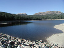
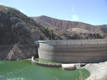
Situated within the vast mountain ranges, thousand of miles of streams flow into numerous lakes and man-made reservoirs. The lakes and reservoirs range in size from a few acre-feet to large bodies of water such as Lake Powell and the Great Salt Lake, each containing about 28 million acre-feet of water. The State Engineer lists over 500 dams that impound water for agriculture and municipal use. Within the High Uinta mountains are hundreds of natural lakes and many large man-made reservoirs.
During the fall months the snowpack is exhausted and the stream flows are reduced, in many cases, to a trickle. Water releases from lakes and reservoirs for farming and municipal uses reduce the water levels behind man-made dams. The normal occurrence matches the four-season climate. During the winter months snowpack builds in the mountain ranges; spring brings the snowmelt that is captured in lakes and reservoirs; during the summer growing season the water is consumed for growing crops and urban greenery; and finally during the fall months the cycle is completed.
At the higher mountain elevations, fishermen in autumn try their luck before winter snowfall and temperatures drop. People dressed in red can be seen scouring the mountains in pursuit of the hunt. Speed boat drivers towing water skiers enjoy the pleasure of the outdoors at the many popular recreation reservoirs. Soon it will be time to store their boats and fishing poles and dust off their winter skis.
|
|
The southern part of the state has faired better this year. According to public relations person Marc Mortensen, St. George received normal precipitation this year and with the publics help in conserving water, their water supply is in good shape this year. By in large, residents and businesses conserved water this year -- up to 15 percent some months over last year, Mortensen said. The southern part of the state was helped by summer monsoon precipitation. Because of the favorable weather and conservation, we have been able to rest some of our wells this fall.
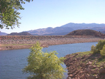
Water managers in the northern part of the state have a different story. According to Weber Basin Water Conservancy District general manager Tage Flint, upstream storage is 35 percent at the end of the water year -- a decline of 5 percent over last years 40 percent. The district is counting on a better winter to improve the situation next year, but Flint isnt encouraged by the late summer precipitation. Hopefully this fall is no indication of the coming winter, says Flint, noting that its been hot and dry during August and September with very little precipitation. September was the fourth warmest and driest on record and water usage rose correspondingly. We have never seen demand as high (late September) as this year, says Flint. The difference is that there was moisture last year, but not this year. Flints observations are shared by most water officials in northern Utah.
Lower than normal reservoir levels are common throughout the northern part of the state. Water storage in the 152,000 acre-foot Deer Creek Reservoir is down to less than 80,000 acre-feet, 17 percent below the historic average and approximately 14 percent below the volume at this time last year. The Provo River Water Users Association owns approximately 59,158 acre-feet and the Central Utah Water Conservancy District 25,825 acre-feet of the remaining water in the reservoir. General Manager Keith Denos is cautious about next years water outlook, Deer Creek Reservoir is very low this year -- somewhere in the bottom 5 of the last 40 years. He is concerned that if the watersheds dont receive rain before it freezes, it could reduce the run-off next spring. The parched soil could soak up much of the snowmelt next spring reducing the runoff into the reservoir, he warns. Its too early to tell, but its not looking good. Denos believes that it will take a wet fall, a better than average snowpack and runoff to improve the water supply outlook for the Associations shareholders next year.
|
|
The autumn colors, the cooler nights and shorter days signal the end of the water year and the beginning of a new one. Water managers hope that the coming water year provides more favorable water supply than the one just completed. For now it doesnt help to worry, so enjoy the autumn colors.