The Bear River
On August 16, 1888 a cannon was fired in Brigham City to salute the signing of the contract to build the canals to bring Bear River water to Box Elder County, Utah.
LeRoy W. Hooton, Jr.
November 1, 2000
Introduction
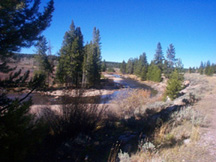
The Bear River begins in the High Uintahs, and then gaining volume flows through 3 states before discharging into the Great Salt Lake. The river travels 500 miles through parts of Wyoming and Idaho before again entering Utah to complete its journey. The basin yields about 1.4 million acre-feet of water with over one-half of it used (depletions).
|
|
Today, some say that the Bear River is one of the last untapped water resources left in the State of Utah. Some vow to keep it that way. The State Legislature has passed legislation to develop the river, while local residents in Cache and Box Elder Counties and environmental organizations oppose the development of the river. The Salt Lake based Rivers Council headed by Zach Flankel leads the organized opposition. As the issue heats up, neither side seems willing to compromise. The Bear River has been characterized as one of the important inland rivers in the Western Hemisphere and during the next few years its future may be decided.
Bear River water development for municipal use along the Wasatch Front is a controversial issue. In the stream of arguments, Salt Lake City is mistakenly identified as one of the entities trying to develop the Bear River. Salt Lake City is not involved in any way in the development of this resource. Notwithstanding this fact, it is an issue affecting nearly all of the residents along the Wasatch Front.
Early History
|
|
The following information, in part, was garnered from the book entitled, The Development of Institutions Under Irrigation, written by George Thomas, A.B., Ph.D, Professor of Economics, University of Utah, published by The MacMillan Company, New York, 1920. Professor Thomas later became president of the university.
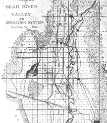
The Bear River valley was described by Professor Thomas as a sage brush flat utilized principally for grazing of cattle and sheep and as a wild run for jackrabbits. It was necessary to tap the Bear River and construct canals in order to develop agricultural enterprises in this northern Utah valley.
The canal system was first surveyed in 1868, but organizing and financing of the project were not accomplished until 1889 when the Bear Lake and River Water Works and Irrigation Company was incorporated. Two-million dollars was secured to construct the canals to supply water for domestic, municipal and manufacturing uses to Ogden City, Corinne City, Bear River City and other cities and villages in the valley. Bonds were sold to finance the venture. The diversion dam was constructed in 1889-90 where the Bear River leaves the Cache Valley (Cache divide). Diversions were made into two canals, each having a design capacity of 1,000 cubic feet per second, constructed along the solid ledges of limestone on both sides of the gorge. However, various lawsuits, disputes and the bankruptcy of the lending institution hampered the early completion of the project. Before the project stopped due to financial problems, as many as 7,000 workers were employed in completing the first twelve miles of the two canals. Water was first turned into the partially completed canal system in 1892.
Renewing construction, the company was reorganized in 1894 as the Bear River Irrigation and Ogden Water Works Company. The new company entered into a partnership with the Corinne Mill and Canal Stock Company, which owned 45,000 acres of land to be served by the canal system. This partnership successfully advertised the sale of land and water together, selling a single acre at $30 per acre or 20 acre tracts at $20 per acre.
It could be argued that the European sugar beet made the greatest contribution to the success of the canal system. During the turn of the century the sugar beet became the mainstay of irrigated
|
|
Despite the early struggle to develop the Bear River, it proved a boon to northern Utah. In 1920, Professor Thomas described the valley as one of the richest and most fertile agricultural regions in the great West. However, the irony of this success is that the original bondholders did not reap their share of the wealth. Most of the investors were Quakers living in Great Britain and they lost most of the money they invested in the irrigation project. According to Professor Thomas, It is typical of many irrigation schemes in the arid West, and shows how financially disastrous an irrigation scheme may be when uncontrolled by the State or the Federal Government.
Box Elder County 2000
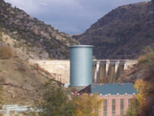
According to Jim Christensen, Manager of the Bear River Conservancy District, the canals are still used today under the ownership of the Bear River Canal Company. The original diversion dam was replaced in 1927 by Utah Power with the Cutler Dam. The two canals, the West and Hammond, today continue to deliver irrigation water to the farmlands in Box Elder County. The
|
|
Its easy to see the difficulty the workers endured in constructing the canal along the gorge formed by the Bear River and why so many were needed to do the work, especially if you consider that the work was accomplished by hand labor and horse power. The Hammond Canal division is made on the left abutment side and the West Canal from the right abutment side of Cutler Dam.
Today as one stands atop the east ridge of the gorge downstream from the dam and observes the far ridge, the West Canal is visible as its hydraulic gradient slopes to the valley below. Then as the gorge widens out, it disappears as it turns westward. The Hammond Canal follows the eastern side of the gorge, crossing SR 30 about one-quarter mile east of the Bear River and closely parallels the railroad tracks down the eastern side of the valley. Its possible to follow both the West and Hammond Canals through the lush fields of Box Elder County.
Today, Box Elder County is one of the states top agricultural areas. According to the 2000 Utah Agricultural Statistics, Box Elder County has the most irrigated farmland in the state with 137,074 acres. It is the number one producer of total grain and has the largest inventory of cattle and calves as of January 1, 1999. In terms of total agricultural cash receipts, Box Elder was third in 1998.
Bear River Development Act
|
|
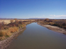
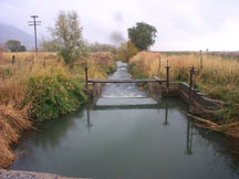 The Hammond Canal near Collinston,
Utah looking south.
The Hammond Canal near Collinston,
Utah looking south.The Act allocates the 220,000 acre-feet of water developed by the Act to the Jordan Valley and Weber Basin Water Conservancy Districts (50,000 acre-feet each), Bear River Water Conservancy District (60,000 acre-feet) and water users in Cache County (60,000 acre-feet). Both Jordan Valley and Weber Basin Conservancy Districts have initiated the purchase of a water treatment plant site and right-of-way to construct a conveyance system southward through Weber and Davis Counties to Salt Lake County.
According to the DWR in its September 10, 1999 report entitled, Bear River Development, The Bear River is one of the few rivers in the state where there is still a developable water supply. The rivers average annual inflow to the Great Salt Lake is over one-million acre-feet. DWR details a four-part development plan, which includes: 1) enlarging Hyrum Reservoir, 2) connecting the Bear River with a canal and/or pipeline from a point somewhere below Cutler Dam to Willard Bay Reservoir, 3) providing conveyance and treatment facilities to deliver water to the Wasatch Front, and 4) building Honeyville Reservoir. The report listed the four parts in the order they would be constructed. All options include downstream water rights and the delivery requirements to the Bear River Migratory Bird Refuge.
The proposed Honeyville reservoir would be located upstream of I-15 where the Bear River crosses the freeway. The $60 million project would store 117,000 acre-feet of water and extend 13 miles upstream. Other sites being considered are the $27 million Beeton Dam five miles further upstream from the proposed Honeyville site and the $80 million Barrens Dam, located about 5 miles west of Smithfield in Cache County. The Beeton reservoir would impound 49,000 acre-feet and the Barrens 100,000 acre-feet of water. DWR Deputy Director Dennis J. Strong says that the Honeyville reservoir is the lesser cost alternative, but DWR has not limited its choice to this site. At this time all options are under consideration, adds Strong.
The loss of wet and farmlands is a strong argument against a dam on the Bear River. However, retired State Senator John Holmgren does not support the Honeyville site and believes that the Barrens site in Cache County avoids part these problems. On KUTV Take Two news program, Holmgren said, The Amalga (Barrens) site will only take a small amount of farmland that is not really grade A farmland. He further believes that the land could be purchased without condemnation. Most of the land can be bought by a willing buyer -- a willing seller, says Holmgren. The Barrens is his preferred site. However, the Audubon Society is particularly opposed to the Barrens site.
Another site that is beginning to gain acceptance is the Washaki, located northwest of Plymouth, Utah on the east side of I-15. Strong says that this site does not have the wetlands issue, visual impacts and farmland population problems that the Honneyville and Barrens sites have, but, he notes, In the long run its more expensive because of the pumping costs to lift the water to this site.
According to Jordan Valley Water Conservancy District projections, the district will need water from the Bear River as early as 2015. With strong conservation measures, resulting in a 20 percent reduction in outside watering, the date could be extended to 2020. In the mean time, they are developing local resources. DWR studies indicate that municipal and industrial water supply needs will increase along the Wasatch Front during the next 50 years. Even with a 25 percent conservation effort, over 200,000 acre-feet of new water will be needed in Salt Lake County.
Zach Frankel of the Rivers Council disagrees with the need to develop water from the Bear River to meet municipal water supply needs in Salt Lake County. He believes that water demand can be reduced by imposing stronger water conservation measures and converting Salt Lake County irrigation water to municipal water as farmland is urbanized.
|
|
The WBWCD opposes this idea. Ivan W. Flint, General Manager of the district says his board is dead against using Willard Bay as a substitute for other methods of developing the Bear River. Among other reasons, their concerns are water quality and storage capacity. Flint says, When Bear River water is available, its the same time that Weber Basin Project water is available and the WBWCD doesnt have a problem filling the reservoir with Weber Basin water. Therefore, theres no storage space in Willard Bay for Bear River water. He continues, Furthermore, we need the Weber Basin Project water stored in Willard Bay to meet our growth until 2015 when the Bear River water is scheduled to be available. As to if a dam should be built or which dam site is selected, Its DWRs call, says Flint.
Another of their concerns is the effect on water quality. However, DWR believes that this is not a problem, Because Bear River water will be stored in Willard Bay during the high spring run-off and winter months when the Total Dissolved Solids (TDS) are lower, says Strong. Our studies indicate that the water quality during these periods will be about the same as the water stored in Willard Bay. Water from any one of the proposed new reservoirs on the Bear River would have
|
|
Regardless of which option is selected, membrane treatment will be required to use Bear River or Willard Bay water for municipal and industrial purposes. Currently, the desired treatment standard is based on the quality of water from the Provo River. For example, the TDS values for Willard Bay are twice as high as those in Deer Creek Reservoir. Willard Bay TDS values average nearly 600 mg/l and the Bear River values are higher. The secondary drinking water standard for TDS is 500 mgl/l.
Notwithstanding the arguments for and against using Willard Bay, WBWCD seems adamant against using it. Willard Bay is part of the Weber River Project and serves a certain function. Its (Willard Bay) doing a great job and we want to keep it that way, says Flint.
Conclusion
It appears that developing the Bear River is many years and battles away. Its certain that the Bear River will continue to be a controversial issue during the coming years. One wonders in the end, which side will shoot off the cannon?
Selected References
State Water Plan, January 1989, Board of Water Resources
Bear River Development, September 10, 1999, Division of Water Resources
The Development of Institutions Under Irrigation, George Thomas, A.B. Ph.D, The McMillan Company, New York, 1920.
Utah Historical Quarterly, Vol. 47, 1979, Utah State Historical Society.
Utah the Right Place - The Official Centennial History, Thomas G. Alexander, Gibbs-Smith, Salt Lake City, Utah
2000 Utah Agricultural Statistics, Utah Farm Bureau Federation, Sandy Utah.
Utah Division of Water Resources Bear River Water Quality Monitoring Project 1998-1999 Intermin Report (Draft), Montgomery Watson, Salt Lake City, October 1999