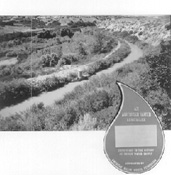
An AWWA National Landmark:The Jordan and Salt Lake City Canal
A paper presented at the Intermountain Section of the American Water Works Association Annual Conference, September 17, 1993, (revised 1998) Snowbird, Utah.
By LeRoy W. Hooton, Jr.
Preface
The Jordan and Salt Lake City Canal remains one of the most important water development projects ever undertaken by Salt Lake City. It allowed the City to enter into exchange contracts with local farmers who had appropriated for irrigation the waters flowing from the Wasatch Canyon streams along eastern Salt Lake County. These exchange contracts provide the City with up to 65,000 acre-feet of water annually of high quality drinking water, and have allowed the Salt Lake Valley to grow and prosper for over 100 years. The mountain streams were the City's only sources of water until the early 1950s when the Provo River Project was completed and the Metropolitan Water District of Salt Lake City began delivering water through the Salt Lake Aqueduct. The exchange agreement waters continue today to be the primary source of supply for over 400,000 people.
Today, the Canal continues to meet its purpose in delivering exchange water during the irrigation season, and is as important to Salt Lake City in 1998 as it was in 1882. This will continue into the future, as the canyon streams provide 60 percent of the City's water supply.
The 28-mile Jordan and Salt Lake City Canal traverses eastern Salt Lake County from a point north of the Jordan Narrows to South Temple and State Street in downtown Salt Lake City. In the beginning it was controversial; however, upon completion in 1882, the Salt Lake Herald called it "one of the greatest days in the history of Salt Lake City."
Early Attempts to Construct Canals
By the year 1860 most of the waters flowing from the various mountain streams were appropriated by the farmers for irrigation; Salt Lake City, as well as the farming community on both sides of the Jordan River, looked to the Jordan River for additional water.
The concept of utilizing Jordan River water within the Salt Lake Valley was long thought about, however, its elevation along the valley floor prevented its use for irrigation on the majority of the land. The only way to utilize the Jordan River was to divert it through canals at an elevation up-stream that would allow the water to reach the higher bench lands by gravity flow.
The water of the Jordan River was first diverted in 1850, but during the following 20 years, only small ditches were constructed to convey the water to the farmlands.
The following description of early plans to develop the Jordan River was taken from the 1903 Report by the United States Department of Agriculture, entitled, "Irrigation Investigation in Utah:"
"In 1854 a plan for a great navigation, power, and irrigation canal from Utah Lake to Salt Lake City was conceived and was formulated in a law passed by the Territorial Legislature. Although acted upon by the State Legislature, the construction of a canal never developed. The law contemplated one of the largest of the canal plans at that early day. Section 3 of the legislation reads: Said canal shall commence above the rapids in Jordan River, where a dam shall be constructed across said river of sufficient height to cause slack-water navigation to Utah Lake, and proceed as near the base of the mountains on the west of the Great Salt Lake Valley as practicable, to Great Salt Lake; and of sufficient depth and width for the transportation of boats drawing to 2-1/2 feet of water and l2 feet width of hull. There shall also be good and sufficient guard locks and locks for leveling, and waste gates, also large reservoirs with good and sufficient embankments to contain water for irrigation purposes, at all convenient points."
In 1860 a canal was planned which was to take the water from the Gardner Mill Race, one of the small canals built in 1850 on the alignment now occupied by the North Jordan Canal, but extending it farther west. The canal was started at that time and was extended from time to time along that alignment up until 1881, when, as the North Jordan Canal, it reached its present size.
As a result of numerous failures to convey Utah Lake water to the valley's farmlands, an irrigation-district law was passed on January 20, 1865. Under the direction of the County Court, this law allowed the people of any locality to organize themselves into a company and elect officers, levy taxes, build and operate canals.
On February 2, the County Court made an order organizing all of Salt Lake County lying east of the Jordan River into an irrigation district. Surveys were made providing for a canal 20 feet wide on the bottom, 3 feet deep, and covering 24,750 acres. This plan, like the others, failed. The real development of the Jordan Valley began in 1870, when the South Jordan Canal was begun and completed in 1875. In the meantime, the other canals on the west side were also being excavated.
During 1872 the present Utah and Salt Lake Canal, South Jordan and North Jordan Canals were begun through county aid to construction.
In 1878 the East Jordan Canal Company was organized and incorporated, and began constructing its canal to irrigate the land on the east side of the Jordan River.
Salt Lake City Seeks New Water Supplies
The municipal water needs of Salt Lake City forced the City Council to look at the Jordan River for an additional supply, and the idea was first suggested by Alderman Sheets in a City Council meeting of August 9, 1864. He noted that "In order to bring the waters of the Jordan River into the Salt Lake Valley, it was necessary to construct a canal at the northern edge of Utah Lake which had sufficient elevation to provide flow to the eastern boundaries of Salt Lake City."
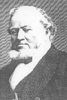
On January 10, 1865 Brigham Young spoke of the beneficial results that could be accrued by irrigating and cultivating increased amounts of land. He said that "...the
bringing of the waters of Utah Lake would be the means of sustaining a population in the Great Salt Lake County of l00,000 inhabitants."
Brigham Young
On September 15, 1879 Alderman Raleigh discussed the subject of obtaining a major supply of water for the city. The subject was referred to a special committee of five to be appointed by the mayor. Their instructions were to examine the practicability of taking stock or interest in canals being constructed in the southern part of Salt Lake County, which were taking water out of the Jordan River. Also, they were to examine the feasibility of bringing East Canyon Creek located in Morgan County to the City by tunneling.
The committee reported to the mayor on October 21, 1879 that they had investigated the construction of a contemplated canal for conveying water from the Jordan River to the City. Further, they reported that, "...the past season has fully demonstrated the fact that the supply water from all sources to this city, (or) in any dry season, even when managed with frugality and distributed to its full capacity both day and night, is wholly inadequate ... for without water all efforts will be futile.
At the conclusion of the committee report, Mayor Little, Alderman Raleigh, and Jesse Fox, City Surveyor, were appointed to a committee to negotiate with land owners to acquire the contemplated canal right-of-way as recommended by the Council.
During the year of 1879 actual construction of the Jordan and Salt Lake City Canal commenced, and it was completed in l882.
The completion of the of the Canal and water flowing into the City Creek Aqueduct was reported by the Salt Lake Herald on July 12, 1882, in an article entitled "Salt Lake and Jordan Canal, An Immense Benefit to Salt Lake City:"
"...Arriving at the mouth of the flume we found a stream of large volume pouring into the City Creek stone culvert, from which the citizens north and west of East Temple Street obtain their supply for irrigation. The proof was directly under our eyes that, but for the Salt Lake and Jordan Canal there would have been a water famine this season, the stream flowing from City Creek being like a thread compared to that from the flume, and in a few weeks it will be nearly, if not quite, entirely dry. In fact it is almost so now. What are the evidences of its success? Its object was to convey a body of water for irrigation into this city for the relief of the inhabitants. The object is accomplished as a large body of aqueous fluid flows through and can be at any time increased, if needed... A few people - very few- overlooking the necessity of manifesting a largeness of soul that would lead to a consideration of the general weal, object on the grounds of the water of Jordan being impure compared with heretofore used. The answer lies in the increase of quantity for irrigation and the availability of other sources of supply - for culinary purposes...."
The Benefits of the Canal
The completion of the Jordan and Salt Lake Canal paved the way for further water development. Relieving City Creek of supplying both the culinary and irrigation needs of Salt Lake
City, it allowed the City to provide more culinary water within the piped City Creek distribution system that was constructed in 1876. Later in 1888 the canal provided the means for the City to
enter into an exchange agreement with the Parleys Water Users. The City agreed to exchange Utah Lake water from the Jordan and Salt Lake City Canal in turn for the use of the Parleys stream flow. This worked to
both parties' benefit; the City gained the right to use the high quality mountain water, and the farmers were assured a firm water supply to irrigate crops during the late
summer months and drought periods from the stored water in Utah Lake.
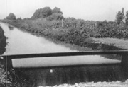
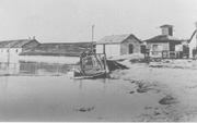
Jordan & Salt Lake Canal looking south at 1100 East 1200 South. Cira 1900.
As the City's water needs continued to grow, in the 1890s the City planned for additional exchange agreements with the water appropriators of Big Cottonwood creek. To make additional exchanges the canal had to be enlarged to deliver more water from the Utah Lake-Jordan River. A Water Commission composed of J. Fewson Smith and W.E. Jacobs stated, "Upon the canal depends the solution of our water problem. Put into the condition suggested (improved and extended) it is capable of bringing nearly ninety million gallons daily for use of the City and exchange elsewhere. There is no doubt that from 40 to 50 percent of the Cottonwood stream may be obtained when once the canal's efficiency is established..." Subsequently, at the turn of the century the City entered into the first exchange on Big Cottonwood, with others to follow. With the construction of the Big Cottonwood Conduit, the first diversion from Big Cottonwood creek was made on February 5, 1907 when 35.9 cfs was turned into the conduit.
During the next 30 years, the City acquired nearly all the water in Big Cottonwood, Little Cottonwood and Mill Creek streams through the exchange process. In order to reach the higher ditches along the east bench, the City condemned its way into the East Jordan Canal, acquiring over 20 percent of the Canal's stock. The East Jordan Canal was extended from the Fort Union area to a pump plant built in 1923 at 6200 South above Highland Drive to lift water to the higher ditches irrigated from Big Cottonwood Creek.
Jesse W. Fox
The story of the Jordan and Salt Lake City Canal would not be complete without telling about the human aspect of this water development effort.
Jesse Fox
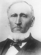
Jesse Fox was the engineer who was responsible for constructing the Canal. His contribution to this project and many other canals during this early history of the Mormon settlement of the Great Basin deserves recognition.
According to his family history entitled, "The Life Of Jesse W. Fox, Sr.," by F. Y. Fox, he was born on his father's farm near Adams Centre, Jefferson County, New York on March 31, 1819. He joined the Mormon Church and moved to Nauvoo in 1844 joining the pioneer migration in 1849 to the Salt Lake valley. Learning surveying as an assistant to the County Surveyor, he was employed by the church in 1850 to survey city lots and farm allotments. Later he would survey for a railroad to Red Butte Canyon to bring foundation stone to construct the Temple; however, in 1852, the railroad idea was abandoned. Jesse Fox became County Surveyor on August 2, 1852 followed by being appointed Territorial Surveyor, which he vacated in 1876.
He became involved in the construction of the Jordan and Salt Lake City Canal when the City decided to find a new source of water from the Jordan River. On August 17, 1879 a mass meeting was held in the Bowery on Temple Square, resulting in a decision to make a preliminary survey of a canal to tap the Jordan River at the Narrows. Surveyor General Fox was employed to make a survey and cost estimate. The proposed 25-mile canal was estimated to cost $280,000. A bond election was held to finance the canal in 1880. During the debate over the bond, the engineering ability of Jesse Fox became an issue. Opponents of the bond attacked him for his involvement in the failed canal from Little Cottonwood Canyon that was intended to carry the granite slabs to the Temple. Some members of the City Council opposed the canal, believing that if the canal was constructed, water would never flow through segments about 5 miles southeast of the City. Ultimately, a bond election was held and approved on April 5, 1880, with five to one in favor. The City Council hired Jesse Fox to construct the canal.
The canal was completed and water flowed from the diversion at the Jordan Narrows to Eagle Gate on July 12, 1882. Despite his critics, he must have been pleased to read the words of the Salt Lake Herald:
"The water from the Jordan and Salt Lake Canal flowed into the City Creek aqueduct east of the head gates on East Temple Street last evening. The canal is practically finished, and today the people of city will be reaping some of the benefits from the investment of their money in this great enterprise. (We) commend Mr. Jesse W. Fox, Engineer, his skill, having the manhood to acknowledge his business and the Herald regards this as one of the greatest days in the history of Salt Lake City."
During the span of his career, Jesse Fox was the Chief Engineer for all five major canals in Salt Lake County. He did the early survey work on the present Weber/ Provo Canal through the Kamas Bench that would later become a key feature of the Provo River Project. He surveyed the early waterworks system in City Creek Canyon in 1872, establishing the diversion, settling tanks and 4 miles of cast iron pipe serving the city's downtown business district.
Jesse Fox left his mark on early water development in the west. His engineering legacy helped shape the history of the Salt Lake Valley.
Utah Lake Pumping Plant
An integral part of the Jordan and Salt Lake City Canal is Utah Lake. The lake, situated in Utah County, covers 93,000 acres at compromise level and provides the water storage necessary to meet the late season irrigation needs of the farmers. It is a fresh water lake; however, due to certain springs and high evaporation rate the lake contain total dissolved solids ranging from 600 to 1500 ppm.
The Jordan River is the outlet of Utah Lake, and flows in a northerly direction to the Great Salt Lake. The Jordan River is nearly flat in grade, which with construction of a dam at the Jordan Narrows, allows the storage of water in Utah Lake. It appears that the first dam in the Jordan River was constructed in 1859 by Ferimortz Little and others to irrigate land on the west side of the river.
According to the 1903 U.S. Department of Agriculture Report entitled "Irrigation Investigations in Utah," Salt Lake County constructed a dam at the Jordan Narrows in 1872. During the next
spring the county court of Utah County asserted that the lake had risen, and it was suggested that the two county courts meet to resolve the problem. Apparently, no resolution was forthcoming, and the
dam was washed out. According to the records of the court of Salt Lake County, "...the head gates washed out, being helped by persons unknown." The issue of a dam in the Jordan River continued to be a point
of contention between the two counties. The dam was rebuilt in the spring of 1874.
Utah Lake Pumping Plant located at the outlet of Utah Lake in Lehi, Utah. Circa 1901
The landowners around the lake continued to complain about the dam and that it flooded their property. Their complaints were investigated by the county court of Salt Lake, with findings that the dam had no effect on the elevation of water in Utah Lake. In 1880, the dam was raised provoking stronger outcries from the Utah County landowners. After several years of dispute, a committee of prominent citizens, who established a compromise elevation of 4,515.799 feet City datum, made an arbitration in 1885. This compromise level held for nearly a century, when after the 1983-86 flood period, a lawsuit settlement in 1985 established a new compromise level at 4489.0455 above sea level.
In order to draw water from Utah Lake when it is below compromise, a pumping plant was constructed during the turn of the century. The plant, located at the outlet of the lake on the Jordan River, originally consisted of four pumps. In 1905, the fifth pump was installed, followed in 1907 by the sixth pump. Shortly thereafter, with the permission of the court, the seventh pump was installed. To accommodate the pumps, two new 175-kilowatt step-down transformers and related equipment were installed. Concerned about meeting its exchange agreement obligations, the City installed a 130 horsepower emergency gasoline engine. According to the "1907 City Engineer's Report", the Utah Lake Pumping Plant was the largest pumping plant in the United States, capable of delivering 700 cubic feet per second, or 452 million gallons per day.
As in the past, the Utah Lake Pumping Plant, continues today to be an important component of the City's water system, feeding water to the Jordan and Salt Lake City Canal and the East Jordan Canal to meet exchange agreement obligations.
The Jordan and Salt Lake City Canal During the 20th Century
During the 20th century the canal became even more important. The City's population continued to grow, demanding more water. The City entered into more exchange contracts with the canyon water owners of Big Cottonwood, Little Cottonwood and Mill Creek. The importance of the canal was stressed by A. F. Dorenus, Engineer Water Supply, in the "1907 City Engineer's Report," in which he pleaded for monies to replace the old wooden flumes and bridges along the canal with suitable concrete structures. "When the canal fails, the city's right to use of the mountain water ceases, and restoration of the use of mountain water is contingent on the restoration of the canal flow." He further added "... no more profitable expenditure of the public money can be made. "
As the City grew, homes encroached on the open canal, replacing the farmlands. By 1914, the City began replacing the canal with buried concrete conduit. The "1917 City Engineer's Report," described the placement of 270 feet of 3x6 foot reinforced concrete conduit through the property near Fifteenth South Street at a cost of $4.11 per linear foot.
Charles W. Wilson, Water Department Superintendent (1951-1980), recollects that during the depression a major effort was made to clean and restore the canal to its original capacity of 150 cubic feet per second. In 1933, the Civil Works Administration (CWA), using 17 sight seeing buses, transported workers to the canal in two shifts per day to cut trees and hand dig the canal. Equipped with mattocks, the workers reconstructed the canal from the Jordan Narrows to the Big Cottonwood Creek spill, widening the bottom of the canal to 18-1/2 feet and shaping the sides at a 1-1/2 slope on each side. Survey crews went ahead of the workers to establish the grades.
Beginning in the 1950s the Salt Lake valley's population moved to the suburbs. During the next 40 years most of the land between Salt Lake City and Draper became developed. Homes and businesses have built up to the canal's right-of-way owned by the City in fee. Operating the canal in an urban setting has become more difficult as the population has encroached on this water conveyance facility. The City's obligation to deliver exchange water has not lessened since that first exchange agreement in 1888 and major improvements are planned to upgrade the canal during the 1990s.
Recognition
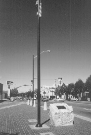
On August 10, 1991, the Canyon Rim Chapter, Sons of Utah Pioneers, dedicated a granite rock monument that recognized the Jordan and Salt Lake City Canal. The Monument is atop the canal (1250 East) in Sugar House on 2100 South Street.
Two years later, the American Water Works Association recognized the Jordan and Salt Lake City Canal as an American Water Landmark. This designation places the Jordan and Salt Lake City
Canal among other famous national landmarks that have contributed to the nation's water supply development. The designation was published in the October 1993 issue of AWWA MainStream. The
construction of this water facility demonstrates the efforts of the early pioneer settlers and their determination to survive in the harsh desert environment of the Salt Lake Valley where the
annual precipitation is less than 16-inches, requiring a firm water supply to grow crops and build a city.
Sugar House Monument erected in 1991.
Conclusion
The Jordan and Salt Lake City Canal is one of the most important water development projects ever undertaken by Salt Lake City. However, as time has passed, it has become only one of many. The City's formation of the Metropolitan Water District of Salt Lake City in 1934 to build the Provo River Project added a major source of stored water. The City's purchase of the artesian basin in Murray and deep wells drilled hundreds of feet below the ground further augmented the City's water supply. Future water will be developed through the Bonneville Unit of the Central Utah Project. Notwithstanding these other supplies, the Jordan and Salt Lake City Canal, continues today, by virtue of the exchange agreements as the corner stone of the City's water supply. The resulting supply of high quality Wasatch mountain water remains the most desirable of all the City's water sources.