|
Bulletin Board Global Positioning System March 22, 2000 Global Positioning System, or GPS, is making an enormous change in the Department of Public Utilities. This new technology allows pinpointing the location of water, sewer and stormwater facilities down to the centimeter. First used in 1996, the Public Utilities purchased its first mapping grade unit for $8,728. It was intended to be used to map water meter locations and had a mapping tolerance accuracy of 3 feet. Once the benefits of GPS were realized, its use was expanded to locate water service lines. Later GPS's use would be expanded to general survey work.
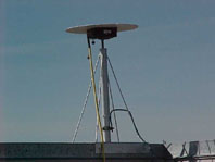
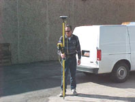
In 1999, with the increasing demand for survey data, the Department purchased a base survey grade unit, and two survey grade receivers and one mapping grade unit. According to Nick, "This allows each of our surveyors to get the information without setting a portable base in the field with every survey," He adds, "Each of our surveyors has a portable rover unit receiving real time on the fly, positioning in the field instantly." The data that comes from the surveyors are now platted at the same coordinate system that all of the Department's maps are generated. The benefits of this system are many-fold. The survey drawings are converted to GIS coverage and imported into the Department's mapping system in the correct location.
Public Utilities' pioneer effort in GPS is helping other government entities as they use the Department's base station for survey needs. State and local governments can only receive the base broadcasting frequency. Salt Lake City owns the frequency, but the range is dedicated to local government. Public Utilities has to date invested $122,000 in GPS technology. The investment will be paid back quickly. Surveying is faster, more efficient and accurate. It has already reduced the need for new survey crews to keep up with the workload. One employee can now do the work of a three-person crew. Questions regarding this article can be addressed to: nick.kryger@ci.slc.ut.us
|