|
May 25, 1999
The Wasatch Fault - An Active Seismic Zone
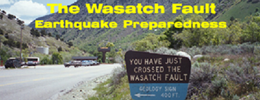
The Wasatch Front is in an active seismic zone stretching from Nephi on the south to Brigham City on the north along the foot of the Wasatch Mountain Range. Nearly all of the states population resides along this narrow band that comprises about 2 percent of the area of the state. The Wasatch Mountains have been described as forming one giant fault scarp along the foot of the range by prolonged movements over millions of years. A fault is defined as a geological break in the materials of the earths crust along which one side of the break has been displaced relative to the other side. Some of the most pronounced fault scarps are located at the mouths of Little Cottonwood and Bells Canyon in eastern Salt Lake County. The fault is intertwined with major water facilities. For example, the Wasatch Fault passes just below the Big Cottonwood Water Treatment Plant at the mouth of Big Cottonwood Canyon. The Salt Lake Aqueduct, a major water conveyance pipeline from Provo Canyon and Deer Creek Reservoir, nearly runs parallel with the fault. The East Bench segment of the Wasatch Fault cuts across nearly all of the city's east to west running water, sewer and stormwater utilities.
Since the Mormon pioneers settled the Salt Lake valley in 1847, there have been numerous earthquakes but none have been destructive. However, because of the geology of the area, experts predict a major earthquake will strike the front sometime in the future. According to the Utah Geological Association, A major earthquake striking the Wasatch Front is not a question of if, but when. As the Salt Lake area continues to grow into a major metropolitan center, the potential for property damage and deaths increases from a destructive earthquake that is predicted to occur sometime in the future.
The Wasatch Fault produces a major quake about every 350 years. The largest measured earthquake of 6.7 on the Richter Scale occurred on October 6, 1909 in the Hansel Valley in northwestern Utah, which was felt over a 30,000 square mile area. There were a number of strong quakes within the Salt Lake City area during May 1910. The largest earthquake measured in Salt Lake County was recorded on September 5, 1962, with the epicenter located in the Magna area. This event was 5.2 on the Richter Scale. There was some minor damage from this event.
There is almost daily seismic activity within the state of Utah. According to the Utah Geological Survey During the period July 1, 1998 through September 30, 1998, the University of Utah Seismographic Stations located 260 earthquakes. Only one was in the magnitude of 4, three were in the rage of magnitude 3 and the others were in the lower ranges. Based on this activity, it appears that about 1200 seismic events occur annually within Utah.
Liquefaction
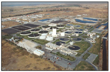
In recent years there has been growing concern about liquefaction in the low-lying areas of the Salt Lake valley. Liquefaction may occur when water-saturated soils are subject to earthquake ground shaking. When soil liquefies, it loses strength and behaves as a viscous liquid (like quicksand) rather than a solid. This can cause buildings to sink into the ground or tilt, empty buried tanks to rise to the ground surface, slope failures, nearly level ground to shift laterally tens of feet, surface subsidence, ground cracking and sand blows. This is of special concern for utility facilities near the Jordan River northward, encompassing the area adjacent to the Great Salt Lake. The City's wastewater treatment plant is located within the liquefaction zone. Major water and sewer lines cross this area.
Salt Lake Citys Utility Infrastructure
|
It has been the policy of the Department of Public Utilities to methodically bring its older key facilities up to current seismic code. Recognizing that the utility infrastructure is critical to the public well being, every attempt is being made to ensure that it will survive an earthquake and continue to provide service during and after an emergency resulting from an earthquake or any other disaster.
Emergency Response Plan
It is further recognized that it is impossible to predict the time, place and extent of damage to utility facilities, therefore, the Department is preparing an Emergency Response Plan to respond to damage resulting from an earthquake. In many cases common sense measures such as securing items from falling, or removing heavy items from the top of storage shelves in the storehouse areas can prevent injury or damage from an earthquake event. This is an on-going effort, and requires constant attention as conditions and personnel are constantly changing. Likewise, emergency preparedness and response training require constant attention as it is easily forgotten in the day to day work of the Department.
Capital Improvements Program
|
The following major structures have been reconstructed over the past years to meet current seismic codes:
- The new Big Cottonwood Conduit, constructed in 1982, was designed with special seismic joint restrainers.
- The Public Utilities Maintenance Complex at 1530 South Jefferson was reconstructed to meet seismic code in 1991. This is the center of operations and maintenance, equipment, maintenance parts and communication.
- The Public Utilities Office Building at 1530 South West Temple was enlarged and reconstructed to meet code in 1990. This is the center of engineering, administration and a communications center.
- The Parleys Water Treatment Plant was enlarged and reconstructed to meet code in 1991.
-
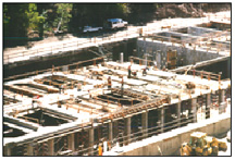
All of the Departments distribution reservoirs were evaluated in 1992 and a program implemented to make seismic improvements. The first tanks to be seismically retrofitted were the two concrete East Bench tanks in 1996. Experience has shown that steel distribution tanks can buckle or move off their foundations during an earthquake. To prevent this each of the Department's tanks is retrofitted with a new foundation and then fastened to the new foundation. Four steel tanks were completed in 1997. Currently (1999) another 7 steel tanks are being retrofitted.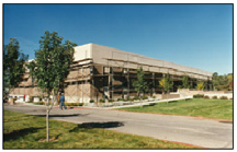
Public Utilities Office Building was retrofitted in 1990 to meet seismic codes.
- All three of the Departments storage dams, Mt. Dell, Lake Mary Phoebe and Twin Lakes have been studied and are in compliance with the state of Utahs high hazard dam safety standards, which includes seismic analysis.
- The 5th South 1500 East and Samuel Park Reservoirs were reconstructed and brought up to code in 1996 and 1998 respectively.
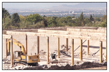
- The Big Cottonwood Water Treatment Plant and Filter Building were reconstructed to code in 1997-98. New structures were designed and constructed to Zone 4 requirements.
- Under the Citys 1982 Wastewater 201 Facilities Plan, all of the work at the Water Reclamation Plant has been done under the new code. A detailed Earthquake and Liquefaction Engineering study was conducted in 1991. Subsequently, extensive seismic improvements were made to the 1953- built main pumping plant, including a new building to house the back-up power generator. However, there are major unit processes that were constructed in 1965 prior to the new code requirements. Every effort is being made to strengthen the wastewater treatment facility to withstand a major earthquake and potential liquefaction. An emergency pumping plan has been adopted to provide for emergency pumping to by-pass the plant in the event that the main pumping plant or treatment facility cannot function due to an earthquake event.
New Utility Facilities
One of the reasons that the Jordan Aqueduct was located on the west side of the Salt Lake valley was to provide two aqueducts feeding water to the valley. The Salt Lake Aqueduct on the east side parallels the Wasatch Fault, and its less likely that both aqueducts would fail in the event of an earthquake.
The US Army Corps of Engineers has constructed the 21,500 acre-foot Little Dell Dam to meet seismic standards. This new facility is designed to withstand a major earthquake.
All new construction since1970 has met the Zone 3 code. In time, as the older facilities are replaced or upgraded, these critical lifeline water, sewer and stromwater structures will meet the code.
Conclusion
Based on current information, the chances for a major earthquake of a magnitude 7.0 or greater along the Wasatch Front is 30 percent in 100 years. The probability of such an earthquake on the Wasatch Fault in Salt Lake City may be as high as 57 per cent in 100 years. A 7.0 or greater earthquake would cause severe damage to the highly populated Salt Lake valley. Its a risk we choose when we live in the shadow of the Wasatch Mountain Range. Building code
|
Select References
Utah Geological Survey Fault Forum, Sandra N. Eldredge
Environmental Geology of the Wasatch Front 1971, Utah Geological Association Publication, p.42H, 44H
Liquefaction, www.ugs.state.ut.us/liquefy.htm
Environmental Geology of the Wasatch Front, 1971, UGA Publication, p.H14
Utah Geological Survey, www.ugs.state.us.us/presseq.htm; January 16, 1996, "Major Wasatch Front Eathquake More Likely Than Originally Throught."
Questions regarding this article can be directed to: leroy.hooton@ci.slc.ut.us