Measuring the Wasatch Snowpack
February 2, 1999
|
|
Excerpts from an early article written by A.A. Justice, Assistant Surveyor U.S. Weather Bureau, in the 1915 Municipal Record, describes a snow survey in the City Creek Watershed:
On the morning of March 18 we started up the canyon in a wagon furnished by the city, and were able to ride to a point about one mile above "High Line." Here the wagon turned back, and we loaded our tent, beds and supplies on a sled previously made for this purpose, and started up the canyon. The sled was made with a pair of skis as runners, and when loaded with our outfit weighed about 275 pounds. (It took four days to reach the base camp by Clayton's cabin at what is called the "First Lake.")
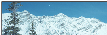
The following four days, from March 22 to 25 inclusive, we made measurements of the snow. The region embracing the areas where measurements were made is about four square miles, and has an elevation between 8500 and 9500 feet. The same places were selected for measurements as last year, namely, among the aspen trees. It was found by experience that the quaking aspens furnish about the only satisfactory places for measurements. The snow among these trees is usually smooth and undisturbed, while among the pines it is of irregular depths, and the pines catch the snow on their boughs and scatter it in rings around the trees. Over places where there are no trees the snow is usually light, or is drifted, and in either case measurements would be useless.
Each measurement consisted in the depth of the snow in inches and the water equivalent in inches. A tube 51 inches long and 2-5/8 inches in diameter was shoved down into the snow to the ground. The core of snow thus caught was weighed on a spring balance, which gave the water equivalent in inches. A field book was carried along, and each measurement was entered and given a number.
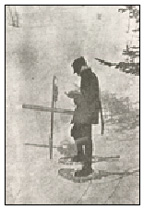
Snow survey - Circa 1926.
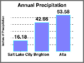
Two hundred and ninety-six measurements were made for depth and density, the average depth being 45.9 inches and the average water equivalent 14.2 inches. The ratio of water to snow was 31%.
Last year 160 measurements were made, the average depth being 59.9 inches, and the average water equivalent 20.4 inches, the ratio of water to snow 34%.
A comparison of the results of the two year's surveys shows that there is 30% less water this year than last year in the snow, and the condition of the snow indicates a more rapid melting this year with the same weather conditions as last.
Mr. Hammond was an agreeable and willing worker, and was just the man for the job. Being the stronger, he always took the heavier part of the load. A better man could not be found. We left camp at 9 a.m. March 26, and pulled our outfit down to within a short distance of North Fork, where it still remains.
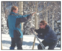
Much has changed since this 1915 snow survey in City Creek; yet much remains the same. Today, Dan Schenck, Hydrologist, and Larry Alserda, Assistant Hydrologist, are responsible for snow measures, run-off forecasts, stream flow measurements and records. The work they perform is no less important today than it was in the past. Today, snowpack measurements are used to forecast the water supply for over 500,000 people, water releases from reservoirs and flood control action.
Replacing the hand drawn sled is a SnowCat, and on occasion a helicopter to transport Schenck and Alserda to the snow courses. Instead of taking nearly a week to do one canyon, 12 different snow courses are measured over a 3 to 4 day period. What hasnt changed is the basic tools; such as snowshoes, measuring tube and scale and the love of the outdoors. In the past, permanent records were hand written, but now computers record data, analyze it and produced charts.
Sometimes, snowpack measurements gain national headlines. During the 1983 spring flood, Dan Schenck was a key person providing information to government officials and the news media. "Little did I know when I decided to become a hydrologist that my education and training would be so important in time of an emergency," says Mr. Schenck. He adds, "As I have gained knowledge and experience in the Wasatch Mountains, I feel that my ability to identify potential flood problems and forecast water supply have improved as I have grown to know these mountains like the back of my hand."
|
Snowpack measurements are now available on the Public Utilities Net Page. Located on the main menu, under the title "Snow Survey" you can now track the water content in the snowpack from City Creek, Emigration, Parleys, Mill Creek, Big Cottonwood and Little Cottonwood Canyons. The data provide comparison from previous years, month by month, indicating if the snowpack is above average, below average or normal for each particular snow course.
More information about this subject can be obtained by e-mail to: dan.schenck@ci.slc.ut.us